Geology is a branch of Earth science concerned with both the liquid and solid Earth, the rocks of which it is composed, and the processes by which they change over time. Geology can also include the study of the solid features of any terrestrial planet or natural satellite such as Mars. Iran and its neighbouring areas are considered as a complex puzzle, in which continental fragments of various origins were assembled and are now separated by discontinuous ophiolitic belts within the Alpine–Himalayan orogenic system At Kavir Iran central region on the volcanic-plutonic belt of central Iran. It is located in Rafsanjan (Kerman province). Igneous rocks in this area include volcanic rocks (andesite, Trachyandesite, basalt and dacite) and igneous rocks are calc-alkaline magma series. Sedimentary area is limestone, shale, conglomerate, sandstone. Filic and argillic alterations are most prevalent have. According to mineralogical studies, mineralization in this region includes iron oxide minerals, for example; Specularity And limonite, as well as secondary sulfide minerals such as borneite, colitis, digenite, and chalcocite, which are substitutes. Pyrite and chalcopyrite. Mineralization has occurred in the form of diffusion, veinlet, void filling and substitution. Potato is one of the most important legumes and constitutes a dominant portion of the global diet. Finally the effect of water stress. In this study, the potato savalan cultivar (StMYB) was the main factor (sandy, clayey soil, compost) and drought stress in four control levels and -0.3, -0.6, -1, and -1.5 MPa of soil water potential in three replicates form of a split plot. We show that in semnan desert the diversity in germplasm indicated that potato cultivars can be developed for production under certain degrees of drought and soil physical properties.
This is an Open Access article, distributed under the terms of the Creative Commons Attribution 4.0 International License (http://creativecommons.org/licenses/by/4.0/), which permits unrestricted use, distribution and reproduction in any medium or format, provided the original work is properly cited.
Geology is the study of the earth, its constituents, the structure of its materials, and the processes that operate on it. An important part of geology is the study of how the earth's materials, structures, processes, and organisms change over time. Many processes, such as landslides, earthquakes, floods, and volcanic eruptions, can be dangerous to humans. Geologists try to better understand these processes in order to avoid building important structures where they may be damaged. Geologists can map areas that have been flooded in the past, and they can also map areas that may be affected by floods in the future. These maps can be used to guide community development and determine the location of flood protection or flood insurance.
People use earth materials every day. They use oil from wells, metAals from mines, and water from streams or underground. Geologists conduct studies that identify rocks containing important metals, identify the minerals that produce them, and plan the methods used to extract metals from the rocks. They do similar things to find and produce oil, natural gas and groundwater.
[1]
Khosroshani, M 2012 The rule of geology for desert formation in Iran. 1 th conference of desert science Iran.
Geologists are those who study how the earth was formed, the characteristics, the events that have taken place since the earth was created, the structure, the composition of rocks and minerals, and its history.
[2]
Asghari, O., Hezarkhani, A. and Soltani, F., 2009. The composion of alteration zonesin the sungun porphyry copper deposie, Iran (based on fluid inclusion studies). ActaGeological Polonica, 59, 93-109.
[2]
Lithology: which studies the stones and their origin. In that method, the formation, origin, classification and composition of rocks are examined. The processes of metamorphism, volcanism, the penetration of igneous masses into the earth and even on the moon and other planets are studied in the branch of igneous lithology and metamorphism. Paleontology: The study of past lives. There are geologists who, by examining fossils and other evidence in rocks and sediments, seek information about the past climate, life history, the history of the earth from the beginning to the present, and the creatures that lived in each period. Physical geology: which studies the external and internal processes of the earth and their effects on the formation of earth shapes and structures.
Geomedicine: Medical geology is a science that examines the relationship between geological factors and human and animal health and the impact of environmental factors on the geographical distribution of related diseases. Geochemistry or geochemistry: the science of determining the relative abundance of elements and their atomic types on Earth; And study the distribution and migration of each element in different parts of the earth (atmosphere, hydrosphere, crust, etc.) as well as in minerals and rocks in order to discover the principles governing this distribution and migration.
2. Economic Geology: Which Studies the Mineral Resources of the Earth
Geophysical geology: the study of earthquakes and their origin and how they originate and behave. Geologists observe phenomena directly in accessible areas. But to study the inner structure of the earth and identify underground reserves and mines, seismic waves are used to study the magnetism, electrical resistance and gravity of rocks. Environmental and geological geology: the study of the environment and the effects of various terrestrial and anthropogenic pollution on it. These branches themselves are also divided into sub-branches Petroleum geology: studies the production and formation of carbon hydrates (oil and gas) as well as the optimal and economical way of extracting them from the depths of the earth's crust using drilling rigs
[3]
Berberian, F., Muir, I. D., Pankurst, R. J. and Berberian, M., 1982, Late Cretaceous and early Miocen Andean_ type Plutonic_activity in northern Makran and Central Iran. J. Geol. Soc. l and V. 39, P. 605-614.
[3]
.
Structural geology: The part of geology that discusses the three-dimensional distribution of the rocks that make up the earth's crust and the history of their deformation. This science also discusses the change and deformation of rocks during compressive and tensile processes. Structural geology mainly talks about the geometric shape and appearance characteristics of different earth structures (faults, folds, etc.). In other words, science is the identification and study of the structures that make up the earth's crust and the cause of their formation. Tectonics studies the internal structure of the earth, how mountain ranges, oceans, faults, folds, earthquakes, and other surface events occur.
Ghorbani M, 2021. Book TitleThe Geology of Iran: Tectonic, Magmatism and Metamorphism.
[18]
.
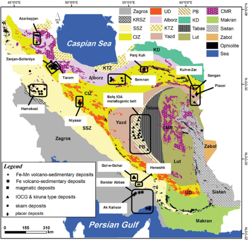
This Figure show distribution of iron deposits according to the type of deposit in the PB, SSZ, Zagros, CIZ, Alborz, Yazd and UD zones. Those in the Alborz and PB include iron oxide À apatite deposits, both volcano-sedimentary and skarn iron deposits are within the SSZ and Zagros zones/belts, and skarn deposits and also IOCG deposits are present within the Alborz, CIZ and UD zones. The Hamekasi and Gol-e-Gohar iron deposits in the SSZ are polygenic in origin. Zagros, Zagros ranges; KRSZ, Kermanshah Radiolarites subzone; SSZ, Sanandaj À Sirjan magmatic À metamorphic zone; UD: Urumieh À Dokhtar magmatic arc; CIM, Central Iranian microcontinent (includes the Yazd, Posht-e-Badam block (PB), Tabas, and Lut blocks); Alborz, Alborz ranges, western Alborz À Azarbayjan, KTZ Khazar À Talesh À Ziveh structural zone; CIZ, Central Iranian zone; Sistan, East Iran ranges; Makran, Makran zone; KD, Kopeh-Dagh ranges; Zabol, Zabol area; and CMR, Cenozoic magmatic
[3]
Berberian, F., Muir, I. D., Pankurst, R. J. and Berberian, M., 1982, Late Cretaceous and early Miocen Andean_ type Plutonic_activity in northern Makran and Central Iran. J. Geol. Soc. l and V. 39, P. 605-614.
[3]
.
Engineering geology: This science by applying geological principles such as studying the mineralogical composition, texture and weathering of rock and soil, understanding the geological history of their formation environment and understanding tectonic processes and structures and recognizing geological hazards by measuring physical and mechanical properties of soil and rock. Analyzing them meets some of the needs of designers. In other words, it is a branch of geology that studies the behavior and properties of the earth's surface materials in terms of resistance to permeable pressures and the possibility of constructing a structure in a specific location of the earth. Water geology: Geologists who study the formation of groundwater aquifers, the movement of water within the earth and how to find them are called geological water. Sedimentology: The materials resulting from the erosion of mountains by wind and ice water are transferred to low areas or sedimentary basins and accumulate there and after rocking, turn into sedimentary rocks. In sedimentology and sediment lithology, the processes of transfer and sedimentation and conversion of sediments to sedimentary rocks are studied
[3]
Berberian, F., Muir, I. D., Pankurst, R. J. and Berberian, M., 1982, Late Cretaceous and early Miocen Andean_ type Plutonic_activity in northern Makran and Central Iran. J. Geol. Soc. l and V. 39, P. 605-614.
[4]
Berberian, M. and King, G. C., 1981. Towards a Paleogeography and tectonic evolution of Iran. Canada jurnal of Earth Sciences, 18, 210-265.
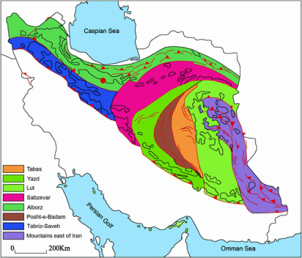
Geological research on the Lut region is very limited. The available information is part of the views of Mr. Stocklin, a geologist of the Geological Survey of Iran, who, while examining Iranian technology, identified two resistant massifs in the Lut region and the north-south-eastern construction axis of Iran. Which forms the mountains of Kerman and Sistan and the mountains of Ghainat and Tabas due to the impact of pressure with this mass is considered. It covers the two sides of the Lut area, so that in terms of construction, Lut is a broken and collapsed pit, which does not seem to have received any pressure on its sediments since the middle of the third period. Central massif study is the key to tectonic problem solving in the eastern part of Iran if the hypothesis is correct. In recent years, Arap has conducted surface geological studies in the Lut region for oil exploration. The existence of a broken line at the foot of Kalut in the northwest-southeast direction is discussed. The faults on both sides of the Lut plain should be clarified in terms of age and the collision of Kalut desert formation with the second and third period sedimentary layers. To be found out.
Ghorbani M, 2021. Book TitleThe Geology of Iran: Tectonic, Magmatism and Metamorphism.
[18]
.
One of the interesting geological issues is the study of clot formations in terms of mineral composition and the third formation method in the region. The resulting sediments have formed fresh deserts, so that since the end of the third period, there may have been a larger area around the Lut region and its weather has changed according to climatic conditions. Sampling and study of desert materials from western mountain plains to Eastern plains should be done and the study of samples should clarify the connection and continuity of sediments at any time and finally find out under what conditions desert formations are formed at the present time. Preliminary research showed that several different desert levels are seen in a section of the east-east that differ in composition.
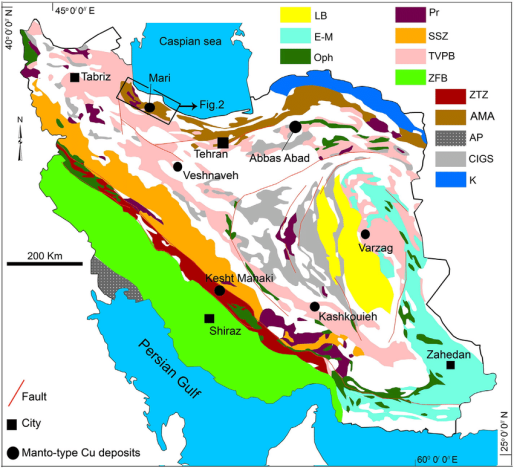
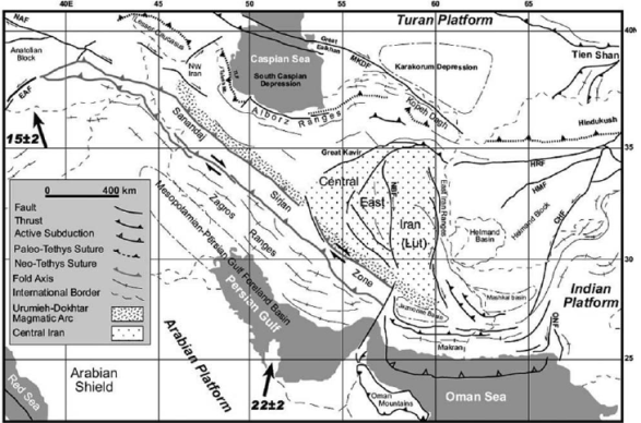
Figure 5. Simplified structural map of Iran and adjacent regions and location of Tethyan sutures (modified after Ramezani &Tucker 2003; actual motion of the Arabian plate relative to the Eurasia from Vernant et al. 2004).
3. Material and Method
Planing Data
An experiment was conducted during 20 December 2023 through March 2024 to assess the effect of planting dates on growth and yield performance of three potential varieties of potato (Savalan varieties) at Plant Physiology research field in Iran, Semnan university. Three planting dates (November 30, December 25 and march 15) and three varieties (var. BARI Alu-35, BARI Alu-40 and BARI Alu-41) were the treatment variables. The experiment was laid out in a randomized complete block design with three replications. Maximum plant height (42.3 cm) was observed in 5 December sowing in var. BARI Alu-40. Highest number of tuber/plant was recorded from December 5 sowing in var. BARI Alu-41.
Potato evapotranspiration (ET) was calculated using the water balance method
[17]
Costa LD, Delle VG, Gianquintoi G, Giovanrdir R, Peressotti A. Yield, water use efficiency and nitrogen uptake in potato: influence of drought stress. Potato Res. 1997; 40: 19-34.
[18]
Ghorbani M, 2021. Book TitleThe Geology of Iran: Tectonic, Magmatism and Metamorphism.
[17, 18]
:
ETm=P+I±S–D–Ro(1)
ETa=P+±S–D–Ro(2)
±ΔS=P+I–D–Ro–ET(ETm)(3)
In this experiment, seed tubers of potato plants are cultivated in soils with different textures in special plots in March. In this research, the effect of different levels of water stress on yield up to tuber size, percentage of dry matter and number of aerial stems, tuber length, tuber diameter, number of potato tuber are investigated in a split plot design with 3 replications. One of the methods of studying the effects of external factors of heat, humidity, cultivation environment, fertilizers and poisons on photosynthesis is by measuring chlorophylls (a, b) and total carotenoids. In this method, one gram of fresh sample of potato leaves is crushed and ground and mixed and homogenized using 10 ml of 80% acetone. One milliliter of it is selected and mixed with 9 milliliters of 80% acetone and centrifuged for 15 minutes at a speed of 8000 revolutions per minute. Then the supernatant phases are separated to measure chlorophyll a and b and carotenoids
[19]
Kheyrodin H. Knowledge of soil science. 2004.
[19]
. The rest of our work is experimenting with a UV spectrophotometer method. Chlorophyll A and B and total carotenoids are determined at wavelengths of 663, 645, and 480 nm. Acetone 89% is used as blank and control (white) and the amount of chlorophylls is calculated from the Arnon equation
[8]
Onder S, Caliskan ME, Onder D, Caliskan S. Different irrigation methods and water stress effects on potato yield and yield components. Agric. Water Manage. 2005; 73: 73-86.
[8]
. The amount of carotenoid is calculated using the Gross equation in 1991. Also, the components, number, length and diameter of the potato tuber and the amount of dry matter of the tuber are determined. Identifying the mutual effects of tissue and culture medium and water stress on average tuber weight, tuber size, number of tuber per plant, number of branches per plant, plant height are among the things that have not been studied at the province level and should be studied
[9]
Kiziloglu FM, Sahin U, Tunc T, Diler S. The effect of deficit irrigation on potato evapotranspiration and tuber yield under cool season and semiarid climatic conditions. Journal of Agronomy 2006; 5: 284-288.
[16]
Simsek M, Tonkaz T, Kacira M, Comiekcioglu N, Dogan Z. The effects of different irrigation regimes on cucumber (Cucumbissalivus L) yield and yield characteristics under open field conditions. Agric. Water Manage. 2005; 73: 173-191.
[9, 16]
. Also, what effect do changes in the concentration and amount of NPK elements, soil texture and water stress have on the quantity and quality of potato texture
[5]
Belanger B, Walsh JR, Richards JE, Milburn PH, Ziadi N. Yield response of two potato cultivars to supplemental irrigation and N fertilization in New Brunswick. Amer J of Potato Res. 2000; 77: 11-21. 31.
[5]
.
4. Results and Discussion
The natural conditions: high temperatures, sandy soils with very low levels of organic matter and nutrients, saline water in the semnan desert region are not favorable, in general, for agriculture. Despite these difficulties, the cultivation of potato (Solanum tuberosum L.) is very successful by the farmers of this region
[10]
Milić S, Bošnjak Dj, Maksimović L, Pejić B, Ninkov J, Zeremski-Škorić T. Potato yield and yield structure depending on irrigation. Ratar. Povrt., 2010; 47: 251-265.
[14]
Pejić B, Mačkić K, Ilin Ž, Kresović B, Gajić B. Effect of different irrigation regimens on water-yield relationships of potato. Contemporary agriculture 2014; 63: 239-244.
[10, 14]
.
Evapotranspiration rate of potato in irrigated conditions (ETm) ranged from 491.3 to 498.6 mm and from 288.1 to 294.4 mm in the non-irrigated conditions (ETa) in 2023 and 2024 respectively
[5]
Belanger B, Walsh JR, Richards JE, Milburn PH, Ziadi N. Yield response of two potato cultivars to supplemental irrigation and N fertilization in New Brunswick. Amer J of Potato Res. 2000; 77: 11-21. 31.
[15]
Unlu M, Kanber R, Senyigit U, Onaran H, Diker K. Trickle and sprinkler irrigation of potato (Solanumtuberosum L.) in the middle Anadolian region of Turkey. Agric. Water Manage. 2006; 79: 43–71.
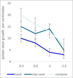
Figure 6. Effects of water stress and soil geological texture on potato growth.
5. Conclusion
The main conclusions are the following:
Geological hazards, such as landslides, collapses, and soil salinization, are induced by outdated irrigation methods in desert agriculture zone such. Based on the loess landslide mechanism induced by irrigation in desert and semiarid regions. Firstly, replace the traditional broad irrigation by water-saving irrigation methods, such as trickle irrigation. Secondly, drought-resistant crops that require less water should be planted. Thirdly, lower the groundwater level. Fourthly, intensify monitoring and early warning in the central growth area
[5]
Belanger B, Walsh JR, Richards JE, Milburn PH, Ziadi N. Yield response of two potato cultivars to supplemental irrigation and N fertilization in New Brunswick. Amer J of Potato Res. 2000; 77: 11-21. 31.
[5]
.
More than 200 iron deposits with about 4 billion tons of iron have been discovered in Iran desert that as effect significantly on potato production in central desert in semnan region.
Major iron oxide districts in the Zagros mountain range, the Gol-e-Gohar city and in the Sanandaj city.
Sirjan magmatic_metamorphic zone and also the Sangan deposit east of Central Iran
[6]
Erdem T, Orta AH, Erdem Y, Okursoy H. Crop water stress index for potato under furrow and drip irrigation systems. Potato Res. 2005; 48: 49-58.
[6]
.
Several smaller iron ore deposits are distributed in the Alborz_Azarbaijan magmatic belt that very important to production of potato.
Based on field studies, the most important crops in the study area are volcanic rocks, including andesite that is important for liberation soil mineral Planting depth plays essential role in formation of stolons and aerial potato stems so that stolons number and ultimately, the yield itself will increase with planting tubers depth (up to approximately 20 cm; depends on cropping conditions)
[17]
Costa LD, Delle VG, Gianquintoi G, Giovanrdir R, Peressotti A. Yield, water use efficiency and nitrogen uptake in potato: influence of drought stress. Potato Res. 1997; 40: 19-34.
[17]
.
The interactions between the factors examined revealed that: potato cultivars differed significantly in their response to drought stress under desert and field conditions. In general, some cultivars were considerably more tolerant to drought stress treatments than others. Plant growth, physiological traits, potato tuber yield were all reduced by stress, and the reduction was much greater at the highest drought stress level in geological desert condition
[12]
Anithakumari AM, Dolstra O, Vosman B, Visser RG, van der Linden CG. In vitro screening and QTL analysis for drought tolerance in diploid potato. Euphytica. 2011; 181(3): 357–69.
[13]
Hassanpanah D. Evaluation of potato advanced cultivars against water deficit stress under in vitro and in vivo conditions. Biotechnology. 2010; 9(2): 164–9.
[12, 13]
.
Microscopic mineralogical evidence shows that the deposit in the host rock is vesicular, diffuse
[7]
Shae JB, Steele DD, Gregory BL. Irrigation scheduling methods for potatoes in the Northern Great Plains. ASAE. 1999; 42: 351-360.
[7]
. It is a substitute and filler of empty space. Mineralization in this area has been done in two stages; in the first stage, the mineral is injected into the rock.
Soil moisture levels can have a huge effect on how your potato yield and quality. Because of its shallow root system, the potato crop is sensitive to drought. High yields of high-quality potatoes can only be achieved by maintaining adequate levels of available soil moisture throughout the growing season
[11]
Joshi R, Wani SH, Singh B, Bohra A, Dar ZA, Lone AA, Pareek A, Singla-Pareek SL. Transcription factors and plants response to drought stress: current understanding and future directions. Front Plant Sci. 2016; 14(7): 1029.
[11]
.
Abbreviations
ET: Evapotranspiration
StMYB: Solanum Tuberosum MYB
Acknowledgments
We thank Dr. M. Rahimi directure faculty of desert science semnan university Iran.
Author Contributions
Hamid Kheyrodin is the sole author. The author read and approved the final manuscript.
Conflicts of Interest
The authors declare no conflicts of interest.
References
[1]
Khosroshani, M 2012 The rule of geology for desert formation in Iran. 1 th conference of desert science Iran.
[2]
Asghari, O., Hezarkhani, A. and Soltani, F., 2009. The composion of alteration zonesin the sungun porphyry copper deposie, Iran (based on fluid inclusion studies). ActaGeological Polonica, 59, 93-109.
[3]
Berberian, F., Muir, I. D., Pankurst, R. J. and Berberian, M., 1982, Late Cretaceous and early Miocen Andean_ type Plutonic_activity in northern Makran and Central Iran. J. Geol. Soc. l and V. 39, P. 605-614.
[4]
Berberian, M. and King, G. C., 1981. Towards a Paleogeography and tectonic evolution of Iran. Canada jurnal of Earth Sciences, 18, 210-265.
[5]
Belanger B, Walsh JR, Richards JE, Milburn PH, Ziadi N. Yield response of two potato cultivars to supplemental irrigation and N fertilization in New Brunswick. Amer J of Potato Res. 2000; 77: 11-21. 31.
[6]
Erdem T, Orta AH, Erdem Y, Okursoy H. Crop water stress index for potato under furrow and drip irrigation systems. Potato Res. 2005; 48: 49-58.
[7]
Shae JB, Steele DD, Gregory BL. Irrigation scheduling methods for potatoes in the Northern Great Plains. ASAE. 1999; 42: 351-360.
[8]
Onder S, Caliskan ME, Onder D, Caliskan S. Different irrigation methods and water stress effects on potato yield and yield components. Agric. Water Manage. 2005; 73: 73-86.
[9]
Kiziloglu FM, Sahin U, Tunc T, Diler S. The effect of deficit irrigation on potato evapotranspiration and tuber yield under cool season and semiarid climatic conditions. Journal of Agronomy 2006; 5: 284-288.
[10]
Milić S, Bošnjak Dj, Maksimović L, Pejić B, Ninkov J, Zeremski-Škorić T. Potato yield and yield structure depending on irrigation. Ratar. Povrt., 2010; 47: 251-265.
[11]
Joshi R, Wani SH, Singh B, Bohra A, Dar ZA, Lone AA, Pareek A, Singla-Pareek SL. Transcription factors and plants response to drought stress: current understanding and future directions. Front Plant Sci. 2016; 14(7): 1029.
[12]
Anithakumari AM, Dolstra O, Vosman B, Visser RG, van der Linden CG. In vitro screening and QTL analysis for drought tolerance in diploid potato. Euphytica. 2011; 181(3): 357–69.
[13]
Hassanpanah D. Evaluation of potato advanced cultivars against water deficit stress under in vitro and in vivo conditions. Biotechnology. 2010; 9(2): 164–9.
[14]
Pejić B, Mačkić K, Ilin Ž, Kresović B, Gajić B. Effect of different irrigation regimens on water-yield relationships of potato. Contemporary agriculture 2014; 63: 239-244.
[15]
Unlu M, Kanber R, Senyigit U, Onaran H, Diker K. Trickle and sprinkler irrigation of potato (Solanumtuberosum L.) in the middle Anadolian region of Turkey. Agric. Water Manage. 2006; 79: 43–71.
[16]
Simsek M, Tonkaz T, Kacira M, Comiekcioglu N, Dogan Z. The effects of different irrigation regimes on cucumber (Cucumbissalivus L) yield and yield characteristics under open field conditions. Agric. Water Manage. 2005; 73: 173-191.
[17]
Costa LD, Delle VG, Gianquintoi G, Giovanrdir R, Peressotti A. Yield, water use efficiency and nitrogen uptake in potato: influence of drought stress. Potato Res. 1997; 40: 19-34.
[18]
Ghorbani M, 2021. Book TitleThe Geology of Iran: Tectonic, Magmatism and Metamorphism.
Kheyrodin, H. (2024). Iran Desert and Geology for Cultivation Potato. American Journal of Applied Scientific Research, 10(1), 17-23. https://doi.org/10.11648/j.ajasr.20241001.12
@article{10.11648/j.ajasr.20241001.12,
  author = {Hamid Kheyrodin},
  title = {Iran Desert and Geology for Cultivation Potato
},
  journal = {American Journal of Applied Scientific Research},
  volume = {10},
  number = {1},
  pages = {17-23},
  doi = {10.11648/j.ajasr.20241001.12},
  url = {https://doi.org/10.11648/j.ajasr.20241001.12},
  eprint = {https://article.sciencepublishinggroup.com/pdf/10.11648.j.ajasr.20241001.12},
  abstract = {Geology is a branch of Earth science concerned with both the liquid and solid Earth, the rocks of which it is composed, and the processes by which they change over time. Geology can also include the study of the solid features of any terrestrial planet or natural satellite such as Mars. Iran and its neighbouring areas are considered as a complex puzzle, in which continental fragments of various origins were assembled and are now separated by discontinuous ophiolitic belts within the Alpine–Himalayan orogenic system At Kavir Iran central region on the volcanic-plutonic belt of central Iran. It is located in Rafsanjan (Kerman province). Igneous rocks in this area include volcanic rocks (andesite, Trachyandesite, basalt and dacite) and igneous rocks are calc-alkaline magma series. Sedimentary area is limestone, shale, conglomerate, sandstone. Filic and argillic alterations are most prevalent have. According to mineralogical studies, mineralization in this region includes iron oxide minerals, for example; Specularity And limonite, as well as secondary sulfide minerals such as borneite, colitis, digenite, and chalcocite, which are substitutes. Pyrite and chalcopyrite. Mineralization has occurred in the form of diffusion, veinlet, void filling and substitution. Potato is one of the most important legumes and constitutes a dominant portion of the global diet. Finally the effect of water stress. In this study, the potato savalan cultivar (StMYB) was the main factor (sandy, clayey soil, compost) and drought stress in four control levels and -0.3, -0.6, -1, and -1.5 MPa of soil water potential in three replicates form of a split plot. We show that in semnan desert the diversity in germplasm indicated that potato cultivars can be developed for production under certain degrees of drought and soil physical properties.
},
 year = {2024}
}
TY  - JOUR
T1  - Iran Desert and Geology for Cultivation Potato

AU  - Hamid Kheyrodin
Y1  - 2024/04/11
PY  - 2024
N1  - https://doi.org/10.11648/j.ajasr.20241001.12
DO  - 10.11648/j.ajasr.20241001.12
T2  - American Journal of Applied Scientific Research
JF  - American Journal of Applied Scientific Research
JO  - American Journal of Applied Scientific Research
SP  - 17
EP  - 23
PB  - Science Publishing Group
SN  - 2471-9730
UR  - https://doi.org/10.11648/j.ajasr.20241001.12
AB  - Geology is a branch of Earth science concerned with both the liquid and solid Earth, the rocks of which it is composed, and the processes by which they change over time. Geology can also include the study of the solid features of any terrestrial planet or natural satellite such as Mars. Iran and its neighbouring areas are considered as a complex puzzle, in which continental fragments of various origins were assembled and are now separated by discontinuous ophiolitic belts within the Alpine–Himalayan orogenic system At Kavir Iran central region on the volcanic-plutonic belt of central Iran. It is located in Rafsanjan (Kerman province). Igneous rocks in this area include volcanic rocks (andesite, Trachyandesite, basalt and dacite) and igneous rocks are calc-alkaline magma series. Sedimentary area is limestone, shale, conglomerate, sandstone. Filic and argillic alterations are most prevalent have. According to mineralogical studies, mineralization in this region includes iron oxide minerals, for example; Specularity And limonite, as well as secondary sulfide minerals such as borneite, colitis, digenite, and chalcocite, which are substitutes. Pyrite and chalcopyrite. Mineralization has occurred in the form of diffusion, veinlet, void filling and substitution. Potato is one of the most important legumes and constitutes a dominant portion of the global diet. Finally the effect of water stress. In this study, the potato savalan cultivar (StMYB) was the main factor (sandy, clayey soil, compost) and drought stress in four control levels and -0.3, -0.6, -1, and -1.5 MPa of soil water potential in three replicates form of a split plot. We show that in semnan desert the diversity in germplasm indicated that potato cultivars can be developed for production under certain degrees of drought and soil physical properties.

VL  - 10
IS  - 1
ER  -