Abstract
The study explored hydro-politics comparatively with regional scrutiny and profound global surveys. Hydropolitics emerged as an interesting sub-field of comparative politics during the cold war period in 1970s. While hydro-politics is about state interest in the management of water resources, comparative hydro-politics is about different states interests in the management and cooperation on sharing and ownerships of water resources. Given that water is a trans-boundary resource that is susceptible to risks and conflicts, understanding politics around water resource is critical for the region and the world. The study regionally scrutinized hydro-politics on the case of Ethiopia, Egypt and Sudan using the Grand Ethiopia Renaissance Dam Project (GERD). It argues that the conflicts and tensions around the upstream and downstream countries can be regulated by the Cooperative Framework Agreement (CFA) of 2024 that has clearly articulated the equitable sharing of the water resources from River Nile. The study then analyzed hydro-political theories such as treaty succession and territorial sovereignty in management, sharing and ownership of water resources. Additionally, the study dived into the role of halted Jonglei canal and its impacts on the citizens across Jonglei state. The study also reviewed the role of South Sudan, the role of China and the role of Britain in Nile basin politics. Overall, the study used comparative method, process-tracing and case studies in scrutinizing and surveying hydro-politics in Africa and the world. The study found out that water resources have been associated with tensions, conflicts and wars and thus to avoid these catastrophes, cooperation agreements must be signed and upheld by the states sharing water resources. The eleven countries of the Nile Basin Initiative (NBI) from both the upstream and downstream must all rectify and implement the Cooperative Framework Agreement (CFA) of 2024. This is globally applicable to other countries that are sharing water resources in North America, South America, Europe, Asia, Middle East and Oceanic regions that Cooperative Framework Agreements (CFAs) are useful instruments of peaceful management of shared water resources. While the study noted the influence of Arab Republic of Egypt on the management of water resources, the study concludes that Egypt should join CFA-2024 and negotiates her rights within the framework.
|
Published in
|
International Journal of European Studies (Volume 9, Issue 1)
|
|
DOI
|
10.11648/j.ijes.20250901.14
|
|
Page(s)
|
23-40 |
|
Creative Commons
|

This is an Open Access article, distributed under the terms of the Creative Commons Attribution 4.0 International License (http://creativecommons.org/licenses/by/4.0/), which permits unrestricted use, distribution and reproduction in any medium or format, provided the original work is properly cited.
|
|
Copyright
|
Copyright © The Author(s), 2025. Published by Science Publishing Group
|
Keywords
Hydro-politics, Regional, Scrutiny, Profound, Global, Surveys, Cooperative Framework Agreement, Nile Basin Initiative
1. Introduction
Hydropolitics appeared during the cold war as a very vital branch of comparative politics because of the greatest interest that has been put on water resources in the world. Hydropolitics refers to as the geopolitics of water that involves struggling over the control of water resources by the countries in the world
| [39] | Waterbury, J. (1979). Introduction to Hydropolitics. Netherlands Water Institute. |
[39]
. The concept of hydro-politics was first introduced in a book of John Waterbury in 1979. Hydro refers to water and politic refers to interest and influence
| [26] | Riak, J. (2023). Introduction to Comparative Politics: Political Conundrums and the Changing World. Africa World Books Press. |
[26]
. Thus, Hydropolitics is defined as the politics of water
| [39] | Waterbury, J. (1979). Introduction to Hydropolitics. Netherlands Water Institute. |
[39]
. Most people take water for granted. It rarely came to mind that water had political and economic value which, in today’s circumstances, is now overwhelming its social value.
In early 1990s and mid-2000s, the concept of hydro-politics was further expounded by other critical scholars of the water resources politics. In reviewing of the empirical literature, the concept was applied to analyse conflict and cooperation in several trans-boundary river basins mostly in poor countries, particularly, in Sub-Saharan Africa
| [42] | Zeitoum, M. (2010). Power, Hegemony and Critical Hydropolitics: Trans-boundary Water Management, Principles and Practices. Basic Books. |
[42]
. Peter Mollinga (2008) describes four domains of water politics research: a) everyday politics b) national water politics c) interstate hydro-politics and d) global water politics
| [24] | Molinga, P. (2008). Water, Politics and Development: Framing a Political Sociology of Water Resources Management. Journal of Water Alternatives. Vol 1(1): 7-23. |
[24]
.
To understand the importance of water issues and the links between water and politics, a brief overview of the world water situation is in order. Water covers around 70% of the earth. Fresh water constitutes less than 3% of the world’s total water. Two-thirds of that fresh water is locked in glaciers and polar ice caps. Most of the remaining water resides in soil and underground aquifers. Thus, approximately, 0.01 percent of all water is accessible to the human population. Still, at the present time, water exists in abundance. If the fresh and sea waters were spread evenly, they would cover the globe to a height of 2700 meters. Similarly, the 3% of fresh water, which constitutes the bulk of our supply, would still make a layer of 70 meters high if it were spread evenly
| [37] | Turton, A. (2000). A Cryptic Hydro-political History of the Nile for the Students of Hydropolitics. African Water Issues Research Unit. University of Pretoria. |
[37]
.
Between 1850 and 1990, the world population doubled while water use grew 300 percent. During the past 70 years alone the world population grew by more than 3 billion people: from 2.6 billion in 1950 to over 9 billion in 2020. According to Michael Klare (2002), “if this rate of increase persists, we will soon be using 100 percent of the world’s available supply probably by the mid-22
nd century”
| [16] | Klare, M. (2002). Resources Wars: The New Landscape of Global Conflict. Henry Hott and Company. |
[16]
. To complicate matters, water is a source of inequality both in terms of distribution and of consumption. With 22% of the world’s population, China accounts for 7 percent of its renewable freshwater; Canada, with a half percent of the world’s population, accounts for 9% of the world’s renewable fresh water
| [16] | Klare, M. (2002). Resources Wars: The New Landscape of Global Conflict. Henry Hott and Company. |
[16]
. Just ten countries hold more than half the fresh water available on the planet. Meanwhile, global population growth is heavily concentrated in North Africa, South Africa, the Middle East and South Asia, where the supply of water is already proving inadequate for many human needs”
| [11] | Ezbakha, F and Brehaut, C. (2021). Hydropolitics Remains as Politics. Palgrave. |
[11]
. Within the next twenty-five years, one-third of the world’s population will experience severe water scarcity.
It is helpful to know that water scarce-countries are defined as those with less than one thousand cubic meters available per person per year, and water-stressed ones as those with less than five hundred cubic meters per person per year
| [11] | Ezbakha, F and Brehaut, C. (2021). Hydropolitics Remains as Politics. Palgrave. |
[11]
. The discrepancy between the extremes aforementioned constitutes what may be termed a structure of water-based global apartheid which many states are beginning to see. In such a global inequality and the local challenges, it engenders, the potential for water-based transnational conflicts should be taken seriously. The urgency of this situation can be explained by the fact that there are 128 trans-boundary rivers worldwide share by 153 countries. These trans-boundary rivers account for 60% of the world’s freshwater flows. Their basins cover 47% of the landmass and 38% of borders are made of water. About 40% of the world’s population is living in river basins shared by many countries. In view of the global climate change and the anticipated alteration of precipitation patterns that will entail, the potential for water-based hardship and water-based conflict is likely to increase in many regions. Perhaps most prominent are the Middle East around the Tigris and the Euphrates River basins and northeast Africa in the River Nile basin. Why is this the case? What is hydro-politics? Why is hydro-politics critical? What are these hydro-states? What are the tensions and conflicts associated with hydro-politics? What theories and treaties govern water resources? What are the impacts of halted Jonglei canal? Does South Sudan have role in Nile basin initiative countries? Who are the actors in hydro-politics in Africa? These questions shall be attempted in this study. The study is organized as follows: section one introduces the study. Section two discusses the characteristics of hydro-states. Section three discusses common differences amongst Nile Basin Initiative (NBI) countries. Section four discusses theories of hydro-politics. Section five analyses water resources treaties signed. Section six numerates upstream and downstream countries’ politics. Section seven compares Ethiopia, Egypt and Sudan on Grand Ethiopia Renaissance Dam (GERD) hydro-politics. Section eight discusses the genesis and impacts of Jonglei canal project. Section nine discusses the role of South Sudan in Nile Basin countries’ politics. Section ten analyses the role of China in Nile Basin politics. Section eleven discusses the role of Britain in Nile Basin politics and section twelve concludes the study.
2. Characteristics of Hydro States
Hydro-states are states that are consumed by the politics of water. They have some characteristics, which are important and should be discussed in this study. The following are the characteristics of these Hydro-states:
1) Poverty Ridden. Most of Hydro-states are very poor countries. From China to Thailand, North Korea, Philippines, Indonesia, Egypt, Sudan, Eritrea, Ethiopia, South Sudan, Uganda etc., these countries have low Gross Domestic Product (GDP) per capita. Although some of these countries have a growing GDP per capita, the trickle-down effect is limited.
2) Post-Colonial. The majority of Hydro-states are former colonies of the great powers. All the above-named countries except Ethiopia were colonized by various great Western and Eastern powers and continued to be influenced by the former colonial policies.
3) Conflict Perennial. We have seen countries such as China, North Korea, Sudan, Egypt, South Sudan, Ethiopia and Uganda drawn into conflicts. Tension over the South China Sea poses a significant risk of conflict with China. China, Taiwan, Vietnam, Malaysia, Brunei, and the Philippines have competing territorial and jurisdictional claims, particularly over rights to exploit the region's possibly extensive reserves of oil and gas.
4) Border Disputes: As already seen with China on jurisdictional claims over the South China Sea, borders disputes are common with Hydro-states. Countries such as North Korea, Egypt, Sudan, South Sudan, Ethiopia, Eritrea, and Uganda also have unresolved border disputes.
5) Developing Economies: All the Hydro-states except China and North Korea are developing countries. Indeed, most of them are middle- and lower-income economies.
6) Kleptocrats: All the Hydro-states are run by bunch of juntas and newly emerged & decorated authoritarian leaders. Public decisions are personalized and the leaders are notoriously corrupt, abusers of human rights and ruled with impunity.
Nile Basin Initiative (NBI) Countries
The Nile Basin Initiative (NBI) is a partnership among the Nile Riparian states that “seeks to develop the river in a cooperative manner, share substantial socioeconomic benefits and promote regional peace and security”
| [30] | Swain, M. (2002). Water Politics and Conflicts. Petersen Publications. |
[30]
. It was formally launched in February 1999 by the water ministers of nine countries that share the river - Egypt, Sudan, Ethiopia, Uganda, Kenya, Tanzania, Burundi, Rwanda, and the Democratic Republic of Congo (DRC), with Eritrea as an observer. South Sudan joined the partnership in 2011.
3. Common Differences Among Nile Basin Initiative (NBI) Countries
NBI countries are considered to be different from one another on 8 broad categories:
1) Size of the Country. A country can be large in terms of its physical size, its population or by the level of its national income. So NBIs have differences in physical size, population and national income. For instance, while the DRC is the large in the size; Egypt is the most populous nation.
2) Historical Background. It is important to understand the colonial background of a country. Colonial rule usually has a significant influence on the preexisting institutions and culture of a country. Some of these influences may have been helpful but others were very harmful. Once colonial rule ended, it took a long time for the newly independent country to find its own foothold. Therefore, it is very important to understand that if a country has colonial history then the culture and socio-economic activities will resemble colonial master.
3) Physical and Human Resources. The number of physical resources, which include land, minerals and other raw materials available to a country can make a huge difference in the life cycle of its population. The countries in the Nile Basin differ very much in terms of their human resources. Some countries may have a small but highly skilled educated and innovative population. While some countries may have a very large but (mainly) a very low skill population with very little or no education at all. Yet, there can be countries, which may have large population with average to high levels of skill and education. Egypt and Kenya both have high skill workforce.
4) Ethnic and Religious Composition. The more diverse a country is, in terms of ethnic and religious composition, the more will be internal strife and political instability. This internal strife and political instability can lead to violent conflicts and even self-destructive wars that wasted numerous valuable resources which could have been used to promote valuable development goals. Sudan, DRC, Ethiopia, Uganda, Kenya, and Tanzania are highly diverse. However, it is Tanzania that has kept its ethnic and religious peace. This is because Tanzania has a strong leadership foundation built by late Mwalimu Julius Nyerere which has promoted ethnic diversity and cohesion.
5) Relative Importance of Public and Private Sectors. The relative importance and size of public and private sector vary a lot in the NBI countries. Countries that have severe shortage of skilled human resources tend to have large public sectors and state-owned enterprises. This is on the assumption that limited skilled manpower cannot compete well in the private sector. The widespread failure of a number of countries with large public sectors raises questions regarding the validity of these claims. Economic policies to promote the same development objectives would be different in countries with different compositions of public and private sectors. Egypt, Kenya and Ethiopia are large economies while Uganda, Rwanda, Tanzania and South Sudan are small economies.
6) Industrial Structure. NBI countries also differ a lot in terms of the size and quality of their industrial structure. The size and type of an industrial sector depend on the policies adopted in the past, which again may have a lot to do with the history of the country. Egypt, Sudan, Ethiopia and Kenya have solid industrial capabilities while Uganda, Tanzania and Rwanda have growing industrial capabilities. Burundi and South Sudan have no any industrial capacity.
7) External Dependence. External dependence can be economic, political or cultural in nature. NBI countries being mostly small and underdeveloped have to depend a lot on developed countries for trade, technology and training. The extent of dependence varies amongst countries and is influenced by the size, history and location of the country. Sudan, South Sudan, Burundi and DRC are mostly surviving on foreign aid due to the way violent conflict has devastated their economies.
8) Political Structure, Power and Interest Groups. NBI countries also vary in terms of the political system and structure, the size of the vested interest group and its influence on the political power structure. Although interest groups are seen to be present in every society to a greater extent than in other countries, a small and powerful elite rule most NBI countries directly or indirectly. Effective social and economic change thus requires that either elite groups be enlisted for support or more powerful democratic forces offset the power of the elite.
4. Theories of Hydro-politics
4.1. Theory of Treaty Succession
Advanced by Valerie Knobelsdorf (1999), the theory of treaty succession has played a central role in debates about modern water governance, particularly; Nile water. It has served as a basis for the refutation of the agreements by some upper riparian states
| [18] | Knobelsdorf, V. (1999). The Nile Water Agreements: Imposition and Impacts of Trans-boundary Legal System. Yale University Press. |
[18]
. In the cases of Ethiopia, Tanzania, Uganda, Kenya, Rwanda, Burundi, DRC and South Sudan, national leaders have directly refused to be bound by the 1929 and 1959 agreements, arguing that these were signed on their nation-states’ behalf and without their consultations and consents
| [17] | Kliot, N. (2012). Water Resources and Conflict in the Middle East. Routledge. |
[17]
. As such, there exists a question as to whether treaty obligations are legally passed from the colonized to the independent states. However, succession manoeuvres exist and these nation-states have made such statements primarily to reserve a future claim to water for development, generally lacking the need or capacity to utilize the river for irrigation purposes, which would be the largest potential draw on Nile water. Indeed, some of the upper riparian states, including Kenya, DRC and Burundi, have not yet taken a firm stance on the validity of the 1959 agreement. Resources excess and lack of capacity have generally prevented the need for some countries to take a solid stance on the issue, although growing water scarcity and newly proposed development projects have begun to change this. Kenya, Uganda and Tanzania, for example, have recently shown their interest in developing small and medium scale irrigation projects around Lake Victoria and some international disagreements have arisen about the rights of local fishermen in the lake and the succession juxtaposition over water control continues. A successful Nile Waters Agreement will likely respond to the lessons learned under the colonially-imposed Agreements. The complexity of interests in the Nile region calls for autonomous solutions that build on localized expertise and community concerns. Although some elements of existing and proposed regimes might prove to be helpful elements in a future agreement, only a specifically tailored approach to Nile governance will be able to address regional priorities while avoiding the “substantial mismatch” of a colonial legal transplant into a unique and complex situation
| [18] | Knobelsdorf, V. (1999). The Nile Water Agreements: Imposition and Impacts of Trans-boundary Legal System. Yale University Press. |
[18]
.
4.2. Theory of Territorial Sovereignty
Advanced by Eric W. Sievers, the theory of territorial sovereignty is central to trans-boundary claims to international freshwater bodies
| [29] | Sievers, E. (2011). Theories on Territorial Sovereignty: A Reappraisal. Journal of Sharia & Law. Vol 41(3): 118-129. |
[29]
. In the governance of land, the issue of territorial sovereignty can be very simple: a sovereign nation-state generally has the right to exert exclusive and unrestricted jurisdiction over land territory within its boundaries. With ambient resources such as water, and especially with the emergence of modern environmental law, this absolute approach to territorial sovereignty becomes more complicated. As in common law property ownership, the law’s consideration of ambient resources does not fit easily into broadly established frameworks. Under the theory of absolute territorial sovereignty, the waters flowing through the boundaries of a nation-state are within the complete domain of that nation-state, which can use them in any manner with no regard for downstream beneficiaries. The former Iraqi government, for example, operated under this approach, justifying its use of the Euphrates river based on its absolute right to do with the water as it pleases
| [31] | Sultana, F. (2019). Water Politics: Governance. Justice and the Right to Water. Routledge. |
[31]
.
Although this theory is usually moderated by international diplomatic concerns or developmental capacity limitations, it is often adopted in times of extreme need, such as widespread drought or war, or in developing countries seeking to utilize all available resources. Among the Nile’s basin nation-states, Ethiopia, Rwanda and South Sudan have most often supported this type of approach, stating that sovereign states have the unconditional right to waters originating or flowing within their borders. This assertion is made stronger by the fact that Ethiopia also serves as the primary catchment area for a majority of the Blue Nile waters, increasing the territorial attachment to the river’s flow within the nation-state. Although international adherence to the doctrine of absolute territorial sovereignty is waning, especially in the allocation of ambient resources, it has been historically upheld in a number of instances. The famous Lake Lanoux Arbitration between France and Spain before the International Court of Justice (ICJ), for example, notes that limitations on territorial integrity are unusual, with judicial decisions recognizing treaty restrictions only where there is clear and convincing evidence…especially when they impair the territorial sovereignty of a state. Under this rule, if the doctrine of absolute territorial sovereignty is adopted in the Nile Basin, it could be limited only by a valid, binding and explicit agreement between sovereign nation-states.
5. Analysis of Nile Water Treaties Signed; 1891, 1906, 1929, 1959, 1993 and 2024
1. The Nile River Basin and Treaties
The Nile river is the longest river in the world. Running through 6,695 km, the Nile is a major trans-boundary water in the globe
| [36] | Tedla, N. (2013). Analysis of Past Agreements on the Nile on View of the Law of Treaty and CFA. Nile Publishers. |
[36]
. The Nile river basin is a confluence of the Blue Nile stemming from Lake Tana in Ethiopia and the White Nile, stemming from Lake Victoria in Uganda. The Ethiopian waters constitute by far the greatest share of the Nile. The Nile and its tributaries flow through eleven countries, Burundi, DRC, Egypt, Eritrea, Ethiopia, Kenya, Rwanda, South Sudan, Sudan, Tanzania, and Uganda. The Basin is home to different people and cultures, and over 550 million people live around it. The fact that the Nile water is the lifeblood for these people makes the cooperation and interactions among the riparian countries complex.
In terms of jurisdiction and development, the Nile has been cited as one of the few international river basins with legal arrangements for sharing the waters, and has at times been portrayed as a possible model for other international river basins. With regards to the use of the river Nile, there is a huge imbalance as the lower riparian countries utilize the most of it and the upstream countries that remained arms-crossed for centuries due to various factors such as the level of economic development and political will. At the very beginning of the twenty-first century, Ethiopia uses less than one percent of the Nile basin waters, while Egypt uses 80 percent. According to the World Bank in 1997 report, the waters of the Nile probably constitute Ethiopia’s greatest natural asset for development
.
During the last decade of the 19th century and in the first two decades of the 20th century, the colonial powers negotiated among themselves over the Nile waters in the spirit of the Berlin Conference of 1884–85. But none of these negotiations took any cognizance of the inherent security, rights and interests of the basin countries themselves.
2. The 1891 Anglo-Italian Protocol
In terms of the 1891 Anglo-Italian Protocol, Great Britain and Italy demarcated their ‘respective spheres of influence in North-Eastern Africa’
| [36] | Tedla, N. (2013). Analysis of Past Agreements on the Nile on View of the Law of Treaty and CFA. Nile Publishers. |
[36]
. This agreement allowed the United Kingdom (UK) to maintain control over the headwaters of the Tekeze (Atbara) River. Article III of this Protocol sought to protect the Egyptian interest in the Nile waters contributed by the Atbara River, the upper reaches of which fell within the newly acquired Italian possession of Eritrea. The Article is provided as follows:
“The Government of Italy undertakes not to construct on the Atbara any irrigation or other works which might sensibly modify its flow into the Nile”
| [25] | Obengo, J. (2016). Hydropolitics of the Nile: The Case of Ethiopia and Egypt. African Security Review. Vol 25(1): 1-9. |
[25]
.
3. The 1906 Tripartite Agreement between Great Britain, the State of Congo, France and Italy
On May 9, 1906, the United Kingdom and the Independent State of the Congo concluded a Treaty to Re-define their respective spheres of influence in Eastern and Central Africa. Article III of the Treaty provided:
“The Government of the Independent State of Congo undertakes not to construct or allow to be constructed any work over or near the Semliki or Isango Rivers, which would diminish the volume of water entering Lake Albert, except in agreement with the Sudanese Government”
| [18] | Knobelsdorf, V. (1999). The Nile Water Agreements: Imposition and Impacts of Trans-boundary Legal System. Yale University Press. |
[18]
.
On April 3, 1906, the UK, France and Italy secretly signed a tripartite agreement for irrigation in the most controversial of all the Nile Water agreements ceding all all Nile basin interests completely to the British. According to Andrea Batstone (1959), it is the dominating feature of legal relationships concerning the distribution and utilization of the Nile waters today
| [5] | Batstone, R. (1959). Water Tensions and Failure of Cooperation. Wool-smith Publishers. |
[5]
. Luke Godana (1985) adds that the agreement has become the basis of all subsequent water allocations (but) has been viewed differently by various writers”
| [13] | Godana, B. (1985). Africa’s Shared Water Resources: Legal and Institutional Aspects of the Nile, Niger and Senegal River Systems. Francis Printer, Ltd. London. |
[13]
.
4. The Anglo-Egyptian Agreement of 1929
After the formal independence of Egypt had been recognized by the United Kingdom in 1922, the High Commissioner of Great Britain in Cairo, in an Exchange of Note with the Chairman of the Council of Ministers of Egypt recognized the “historical and natural rights” of Egypt over the Nile waters
| [12] | Gamal, T. (2015). Nile Water Agreement. Water Management Institute. Cairo-Egypt. |
[12]
. None of the upstream riparian nations was even mentioned or considered in this assertion of presumptive ‘rights. Not even Ethiopia – at that time, long independent of foreign rule - was consulted or briefed in this comprehensive assumption of rights between Britain and Egypt. Since all the other countries that should rightly have been consulted about this far - reaching agreement were still under colonial rule, they were given no say whatsoever over the water resources that the Nile conferred on them because of their proximity to its waters.
5. The Egyptian-Sudanese Agreement of 1959
The negotiation process that culminated in the 1959 agreement for the full utilization of the Nile Waters was stimulated in the 1940s when the Sudanese rejected the 1929 Anglo-Egyptian agreement that allowed the Sudan to use only what was ‘left over’ once Egypt’s needs had been fully satisfied. Various Sudanese politicians persisted in demanding a modification of the 1929 agreement, which was widely perceived by the Sudanese as being too restrictive of the Sudan’s obvious claims to fair usage of the water of the Nile
| [1] | Abdalla, H. (1971). The 1959 Nile Waters Agreement in Sudanese-Egyptian Relations. Taylor & Francis. |
[1]
. According to this agreement, only Egypt and Sudan were legally recognized for the use and ownership of the Nile waters. In terms of the agreement Egypt would be allocated a lion’s share of the available 55.5 billion cubic of the water while Sudan was to be allocated 18.5 billion cubic.
6. The 1993 Framework for General Cooperation between Egypt and Ethiopia
Signed in 1993 in Cairo between Egypt and Ethiopia, it was the first bilateral framework for cooperation regarding the Nile issues after the colonial period. It was signed by the late Ethiopian prime minister Meles Zenawi and former Egyptian President Hosni Mubarak. The framework stipulated those future negotiations between the two countries concerning the utilization of the waters of the Nile would be based on the rules and principles of international law.
7. The Agreement on the Nile River Basin Cooperative Framework, 2024
On 13th October, 2024, Nile Basin witness a defining moment in the history of the Nile Basin and in the broader story of Nile trans-boundary water cooperation. 13th October 2024 marked the official entry into force of the agreement on the Nile River Basin Cooperative Framework, also known as the Cooperative Framework Agreement (CFA). The status of deposition of instruments of ratification or accession to the CFA and the date of entry into force of the CFA was formally confirmed by the African Union (the Depositary of the CFA) on 4 September 2024, in line with Articles 43 and 45 of the CFA. The Cooperative Framework Agreement, the result of over a decade of negotiations, is a testament to the NBI countries collective determination to harness the River Nile for the benefit of all, ensuring its equitable and sustainable use for generations to come. The Agreement was negotiated amongst nine Nile riparian countries (Burundi, DR Congo, Egypt, Ethiopia, Kenya, Rwanda, Sudan, Tanzania and Uganda), and comes into force after its signature and ratification by five countries (Burundi, Ethiopia, Rwanda, Tanzania, Uganda and South Sudan). One of the key aspects of the CFA is its promotion of trans-boundary cooperation and ensuring that all riparian states have a voice in the management of the river's resources. Water does not recognize borders, and in the face of growing demand and finite resources, cooperation is the only sustainable path forward. This agreement enshrines the principles of collaboration, equitable use, and mutual respect among the countries that share the Nile’s waters. The CFA further establishes a mechanism for peaceful dispute resolution, fostering a culture of dialogue and understanding. This is a model not only for the Nile region but for the world, showcasing how nations can come together to resolve common challenges for the greater good. Another crucial pillar of this framework is equity. The CFA aims to rectify historical imbalances in access to the Nile’s waters and ensure that all Nile Basin countries whether upstream or downstream—can benefit from this shared resource. The CFA 2 recognizes the legitimate needs of all Nile Basin states and commits us to the equitable sharing of these waters in a manner that promotes sustainable development. This agreement represents hope for the future, where each country can grow and prosper without depriving others of the same opportunity. The CFA was negotiated, and all its Articles except one were agreed upon, by all nine members states of the NBI, including Egypt and Sudan. The pending Article was placed in the Annex of the CFA for resolution within 6 months of establishment of the Commission. However, Egypt is tactfully defying the CFA and it has mobilized the five member countries that have ratified the CFA not hold any meeting soon.
8. Aswan High Dam and Egypt Conviction
This high rated dam by the Egypt government has a storage capacity of 164 bcm and a surface area of four thousand square kilometers. Since, it was completed, the dam became one km wide at the base, with a crest height of 111 meters. The length of the crest was 3,6 km and was 40 meters wide
| [41] | Williamson, D. (1958). Taking River Nile in the Hands. British Water Resources Institute-London. |
[41]
. The High Dam power station generated 6.6 billion kWh with an additional 2 billion kWh coming from the Old Aswan and nearly 5 billion kWh coming from thermal generators
| [39] | Waterbury, J. (1979). Introduction to Hydropolitics. Netherlands Water Institute. |
[39]
. The installed capacity is 10 billion kWh.
At the opening ceremony, Sadat's official speech castigated the United States of America (USA) by saying that America's broken promise of 1956 is neither the first nor will it be the last. And Soviet support in building the High Dam is neither the first nor will it be the last, for it is an expression of aspirations for freedom and peace for peoples eager for them and who resist colonialist exploitation and imperial subjugation. America's broken promise is but one link in an unending chain that leaves us no alternative but to believe it represents a political plan designed to thwart the aspirations of the Arab people. For each of America's broken promises “O my brethren - there is a Soviet promise fulfilled or on its way to fulfillment; in every sphere of hope and work; in industry, in land reclamation, in electrification, in armaments, in training, in unconditional and unlimited diplomatic support. For the Soviet Union is confident that its stance is one of defense of liberty and defense of peace”
| [41] | Williamson, D. (1958). Taking River Nile in the Hands. British Water Resources Institute-London. |
[41]
.
Official Egyptian figures on the performance of the Aswan High Dam show annual losses of 11.4 bcm, with 9.4 bcm being attributed to evaporation and the remaining 2 bcm being ascribed to seepage. This seems implausible against the figures that were released by Taher Abu Wafa and Aziz Hanna Labib (senior officials in the High Dam Authority) which show a vertical seepage loss of 48 bcm in the first eight-year period until the substrate was saturated, followed by 6 bcm thereafter. In addition to this, 1 bcm losses were taking place horizontally. Thus, according to these two officials, in recent years one would anticipate at least 5 bcm seepage loss over and above the evaporation losses
| [39] | Waterbury, J. (1979). Introduction to Hydropolitics. Netherlands Water Institute. |
[39]
. Thus, the official loss figures were being under-reported by around 14.4 bcm (9.4 bcm "official" evaporation loss and five bcm seepage loss). In sum, more than half of Egypt's incremental gain from the construction of the Aswan High Dam will be lost in storage
| [26] | Riak, J. (2023). Introduction to Comparative Politics: Political Conundrums and the Changing World. Africa World Books Press. |
[26]
.
Hydroelectric power station installed at the Aswan High Dam had an installed capacity of 10 billion kWh annually from twelve Russian turbines. This ignored the fact that both head and flow rates varied. This in turn is governed by other factors, the most important of which is matching the competing needs of electricity generation and irrigation. The bottom line is that rate of release and available head are not synonymous. It is common practice to minimize water release in January and February when agricultural demands are low so that drainage and irrigation canals can be cleared and maintained. This lasted for forty days with daily releases down to 85-90 mcm. This means that the turbines cannot function at capacity and with industrial demands high, this period has been reduced to twenty-one days during which 3bcm are released to satisfy non-agricultural demands
| [39] | Waterbury, J. (1979). Introduction to Hydropolitics. Netherlands Water Institute. |
[39]
. With the releases being determined largely by the agricultural sector, the level of electricity generation is often insufficient, although the installed capacity exists. The trade-off between the two is highly complex
| [26] | Riak, J. (2023). Introduction to Comparative Politics: Political Conundrums and the Changing World. Africa World Books Press. |
[26]
. As a result, the most power that both the Old Aswan Dam and the Aswan High Dam generate together is 9 billion kWh, of which the Old Dam's share is 2 billion. A 1966 study claimed that on average the High Dam power station would generate 5.7 billion kWh a year
| [39] | Waterbury, J. (1979). Introduction to Hydropolitics. Netherlands Water Institute. |
[39]
.
9. Conundrums of Aswan High Dam
1) Seepage losses. These losses were underestimated. For example, when the Old Aswan Dam was filled in 1902, the reservoir initially lost 120 percent of its capacity, declining over a 30-year period to about nine percent of capacity. This was caused by the losses and porous nature of the underlying soils and rock. It was assumed that the same would happen at the High Dam and assuming the live storage capacity to be 100 bcm, it was estimated that for at least 20 years total losses due to seepage and evaporation would be 124 percent of reservoir capacity. This was expected to stabilize at around 17 percent per annum after 30 years when the substrate reached saturation point
| [26] | Riak, J. (2023). Introduction to Comparative Politics: Political Conundrums and the Changing World. Africa World Books Press. |
[26]
.
2) Evaporative losses from the Aswan High Dam. This happens when taking wind velocity into consideration with equal 40 percent of storage capacity or 4 bcm. It is relevant when the original calculation was that Egypt would gain an additional 7.5 bcm annually from the High Dam as agreed with Sudan. This meant that the gains were in fact much lower than originally anticipated
| [39] | Waterbury, J. (1979). Introduction to Hydropolitics. Netherlands Water Institute. |
[39]
.
3) Changes in hydrostatic pressure. This underground water table would change the overall water balance
| [39] | Waterbury, J. (1979). Introduction to Hydropolitics. Netherlands Water Institute. |
[39]
. What this means is that by building a dam that raises the water table above the prevailing level in geological areas that are characterized by fissures and permeable beds, one reverses the flow of groundwater. Under normal conditions, water flows from the ground to the river, but once a dam is built and the water level is increased, water now flows from the river into the ground, being channeled away in underground fissures and being lost to the overall water balance of the basin.
10. Impacts of Aswan High Dam
1) The dam has not provided the benefits it was designed to bring. In fact, Egypt's water needs are greater than what the High Dam can satisfy, so the idea of the Equatorial Lakes as a source of supply is again gaining credibility
| [26] | Riak, J. (2023). Introduction to Comparative Politics: Political Conundrums and the Changing World. Africa World Books Press. |
[26]
.
2) Evaporative losses at the dam as discussed earlier have resulted in a reduced water quality downstream, with a higher saline content. Water flowing into the dam has a salinity of 200 ppm, and when it leaves, it is 220 ppm. But because of return flows back into the main Nile, salinity around Cairo is 300 ppm
| [39] | Waterbury, J. (1979). Introduction to Hydropolitics. Netherlands Water Institute. |
[39]
.
3) The quiet and serious technical debate over the merits and demerits of the dam were never allowed to take place, because the High Dam Covenant branded such studies as suspect and anti-Egyptian
| [26] | Riak, J. (2023). Introduction to Comparative Politics: Political Conundrums and the Changing World. Africa World Books Press. |
[26]
.
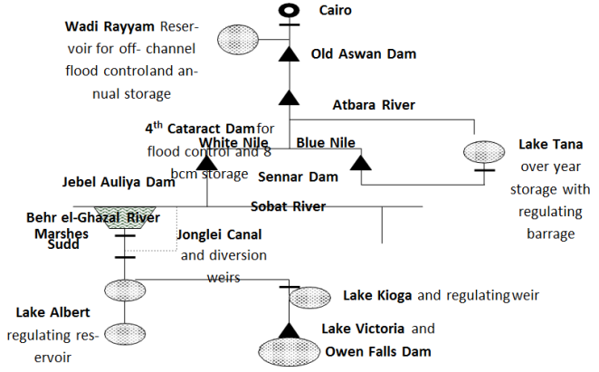
11. Schematization of River Nile in the Hydropolitics
Figure 1. Schematization of River Nile in the Hydropolitics.
6. Upstream and Downstream Countries’ Politics
1. Upstream Countries
Most of the upstream countries are members of the East African Community. They include Ethiopia, Kenya, Uganda, Tanzania, Burundi, Rwanda, South Sudan and DRC. However, Rwanda, Burundi and DRC are core members of Great Lakes Region. These countries have tributes of the River Nile, which flow to Sudan and Egypt. The politics of upstream countries is characterized by the followings:
1) Autocratic regime
2) Repression of the citizens
3) Violent and ethnic Conflict
4) Irredentism and secession tendencies
5) Traditional ownership of Nile Waters (1,727 billion cubic meters)
6) Extreme poverty and underdevelopment
7) Weak economies and poor growth
2. Downstream Countries
Downstream countries are the recipients of Nile waters. They receive 73 billion cubic meters. Egypt receives 55 billion cubic meters while Sudan receives 18 billion cubic meters. The politics of these countries is characterized as follows:
1) Islamic laws
2) Autocratic regimes
3) Revolutionary tendencies
4) Strong economies. Egypt is the second growing economy in Africa after Nigeria and Sudan is the seventh
5) Colonial ownerships of Nile waters
6) Poverty and underdevelopment
7) Arid and semi-arid lands
7. Comparative Analysis of Ethiopia, Egypt and Sudan on Grand Ethiopian Renaissance Dam Project (GERD) Hydro-conflicts
Egypt and Sudan are utterly dependent on the waters of the River Nile. Over the past century both of these desert countries have built several dams and reservoirs, hoping to limit the ravages of droughts and floods, which have so defined their histories. Now Ethiopia, one of eight upriver states and the source of most of the Nile waters has built the largest dam in Africa. Located on the Blue Nile twenty-five miles from the Ethiopian border with Sudan, the Grand Renaissance Dam begins a new chapter in the long, bellicose history of debate on the ownership of the Nile waters, and its effects for the entire region could be profound.
In the fall of 2012 newspapers around the world reported on a Wikileaks
document, surreptitiously acquired from Stratfor, a Texas security company, revealing Egyptian and Sudanese plans to build an airstrip for bombing a dam in the Blue Nile River Gorge in Ethiopia. The Egyptian and Sudanese governments denied the reports. Whether or not there were such plans in 2012, there is a long history of threats and conflicts in the Nile River Basin. Downstream Egypt and Sudan argue that they have historic rights to the water upon which they absolutely depend on and this is a matter of life and death. Indeed, in 1979 Egyptian President Anwar Sadat threatened war on violators of what he saw as his country’s rights to Nile waters
| [9] | Dellapenna, J. (1997). The Nile as a Legal and Political Structure. Peking University. |
[9]
. Upstream countries such as Ethiopia, Kenya, Uganda, Rwanda, Burundi, and Tanzania argue that they too need the water that originates on their lands and they can never compromise their positions.
Since the twelfth century C.E. Christian Ethiopian kings have warned of the Muslim Egyptian Sultans of power to divert waters of the Nile, often in response to religious conflicts. But these were hypothetical threats. At the time of writing this paper, Ethiopia has completed the construction of Grand Ethiopia Renaissance Dam (GERD) and it has filled the dam reservoirs and Ethiopia physically control the Blue Nile Gorge—the primary source of most of the Nile waters.
1. Ethiopia, Egypt, and the Historical Struggle for the Nile’s Waters
Ethiopia and Egypt have had a long relationship of both harmony and discord, the latter the result of religious issues and access to Nile water, among other factors. Ethiopia’s first well documented government was in Aksum, a city-state that controlled a large empire from the Ethiopian highlands across the Red Sea to Yemen. From 100 until 800 C.E. Aksumites participated in Mediterranean and Indian Ocean trade. The cultural relationship between Egypt and Ethiopia was institutionalized when the Aksumite King Ezana converted to Christianity in 330 C.E. For sixteen centuries (until 1959) the Egyptian bishop of the Ethiopian Orthodox Church was appointed by the Egyptian patriarch in Alexandria, often under the influence of the Egyptian government.
Ethiopians were profoundly influenced by the Middle East, even writing their state and geography into Bible stories. The source of the Blue Nile became the Gihon, one of the four rivers that flowed from the Garden of Eden. In the 14th century C.E. myth of national origins connected Ethiopia’s rulers to the Old Testament. In this legend, the Queen of Sheba (Mekedda), journeyed north from Ethiopia to Jerusalem to meet King Solomon in 900 B.C.E. A romantic relationship produced a child, Menelik I, the first in Ethiopia’s Solomonic Dynasty. When Menelik became an adult, despite his father’s wish that he become the next King of Israel, he escaped to Ethiopia with the Ark of the Covenant - the cabinet which contained the tablets of the ten commandments given by God to Moses on Mount Sinai. Menelik stored the Ark on an island in Lake Tana into which the Gihon flows—before it was moved to Aksum, where many Ethiopians believe the Ark remains to this day. Another Ethiopian legend is that Mary and Jesus stayed a night on the same island (Tana Cherquos) during their flight from the Holy Land to Egypt.
The Muslim conquest of Egypt in 640 C.E. put Christian Ethiopia in a defensive position. Because the Ethiopian Orthodox Church remained subordinate to the Orthodox Church in Alexandria and Egypt had become a Muslim country, Ethiopians became suspicious and resentful of the control Egypt had on the appointment of their Christian bishop (abun). Muslim Egyptians also controlled Jerusalem and had the power to expel Ethiopian pilgrims to their holiest of cities.
So, Ethiopians began to claim power over Egypt through control of the Nile. During the crusades, the Ethiopian emperor Lalibela (1190-1225)—who built a new Jerusalem in Ethiopia, safe it from Muslim occupation in magnificent, underground rock-hewn churches—threatened retribution by diverting the Tekeze River from its pathway north into Sudan (where it becomes the Atbara and then joins the Nile). The first Egyptian to write about the potential for an Ethiopian diversion of the Nile was the 13
th century Coptic scholar Jurjis al-Makin (d. 1273)
| [33] | Tadasse, G. (2017). Ethiopia Hydropower Development and Nile Basin Hydropolitics. Aims Press. |
[33]
.
Stories about Ethiopia’s power over the Nile inspired the 14
th-century European legend of Prester John, a wealthy Christian Ethiopian priest-king. In 1510, the legend returned to Ethiopia with Portuguese explorer, Alfonso d’ Albuquerque, who considered the possibility of destroying Egypt by diverting the Nile to the Red Sea. In 1513 d’ Albuquerque even asked the Portuguese king for workers skilled in digging tunnels. Nothing came of the plan
| [6] | Carlson, M. (2016). Hydro-politics and a State. Prentice. |
[6]
.
But conflict between Egypt and Ethiopia continued, often as proxy wars between Christians and Muslims on Ethiopia’s northern or south-eastern borderlands. The 16th century invasion of Ethiopia by Ahmad Gragn, the Muslim imam from the Adal Sultante, was seen as an Egyptian invasion to spur up hydro-conflict. In the 19th century Egypt and Ethiopia fought over control of the Red Sea and upper Nile Basin. The climax came in 1876 at the Battle of Gura in present day Eritrea where the Ethiopians delivered a humiliating defeat to the Egyptian army.
2. Colonial-Era Conflicts over the River Nile
The European partition of Africa in the 1880s added huge complexity to this conflict. It is imperative to recall that Egypt was colonized by England in 1882. Ethiopia defeated the Italians at the Battle of Adwa in 1896 becoming the only African country to retain its independence during the “scramble for Africa.” But colonization created many new states in the Nile Basin (Eritrea, Uganda, Rwanda, Burundi, Kenya, and Tanzania) and set off new competition for resources and territory. Egypt was prized for the Nile Delta, a region of unsurpassed agricultural productivity. After the completion of the Suez Canal in 1869, Egypt was also offered access to the Red Sea and the Indian Ocean. For the British control of Egypt meant more profitable trade with India, its richest colony. For the French, the canal offered quicker access to Indochina, its most lucrative colony.
In the late nineteenth century, since controlling Egypt was the key to Asian wealth, and since Egypt depended on the Nile, controlling the source of the Nile became a major colonial goal. The French-English competition for control of the Nile Basin climaxed in 1898 at Fashoda, Sudan.
The French conceived of the idea of building a dam on the White Nile, so as to undermine British influence further downriver and establish east-west control of the continent. They organized a stupendous pincer movement with one group of soldiers traveling from East Africa across Ethiopia and the other from West Africa across the Congo.
The British heard of the French expedition and having just captured Khartoum ordered a fleet of gun boats and steamers with soldiers under the leadership of General Horatio Herbert Kitchener upriver to Fashoda, the site of the proposed dam. With fewer than 200 men, the French were embarrassed. In 1899 the two colonial powers reached an agreement which designated to France the frontiers of the Congo River and to England the frontiers of the White Nile.
The Fashoda Incident revealed how little Europeans understood about the River Nile. Thinking that most of the Nile waters came from the equatorial lakes (Victoria, Albert, Kyoga, and Edward), the English spent enormous energy on plans to increase White Nile water flows. First called the Garstin Cut and later the Jonglei Canal, the British intended to create a channel that would maximize water transfer through the great swamp-where half of it evaporated
| [22] | Mitchell, J. (2017). The Epistemology of Emotional Experience. Dialectical. Vol 71(5): 192-212. |
[22]
.
One of the most expensive engineering projects in Africa, it was terminated in 1984 by the Sudan People’s Liberation Army, because of the severe disruption it brought to the lives of the indigenous peoples in the Upper Nile region. If the 300-mile-long Jonglei Canal had been completed, it would have increased water flows by nearly 4 billion cubic meters into the White Nile. However, the environmental devastation would have been quite severe to the indigenous communities.
3. Negotiating the Nile: Treaties and Agreements over the Nile Waters
Treaty negotiations about Nile waters started during the colonial era as England tried to maximize agricultural productivity in the delta.
In 1902, the British secured from the Ethiopian Emperor Menelik II an agreement to consult with them on any Blue Nile water projects, especially on Lake Tana. As the controlling imperial power in East Africa, agreements with Kenya, Tanzania, Sudan and Uganda were pro forma, internal colonial matters. After achieving its independence in 1922, Egypt negotiated the Nile Waters Agreement of 1929 with the East African British colonies. This accord established Egypt’s right to 48 billion cubic meters of water flow, all dry season waters, and veto-power over any upriver water management projects. Newly independent Sudan in 1956 was accorded rights to 4 billion cubic meters of water. The Ethiopian monarch was not consulted at least in part because no one understood how much Nile water actually came from Ethiopia.
The 1959 Nile Waters Agreement between Egypt and Sudan was completed before all the upstream states achieved independence: Tanzania (1961), Uganda (1962), Rwanda (1962), Burundi (1962) and Kenya (1963). The signatories of the 1959 Agreement allocated Egypt 55.5 billion cubic meters of water annually while Sudan was allowed 18.5 billion cubic meters. These 74 billion cubic meters represented 99 of the calculated average annual river flow.
The treaty also allowed for the construction of the Aswan High Dam (completed in 1971), the Roseires Dam (completed 1966 on the Blue Nile in Sudan), and the Khashm al-Girba Dam (completed in 1964 on the Atbara River in Sudan). The treaty so negatively affected the upstream states that it provided the inspiration for the Nyerere Doctrine, named after independent Tanzania’s first president, which asserted that former colonies had no obligation to abide by treaties signed for them by Great Britain.
Emperor Haile Selassie was offended by President Nasser’s exclusion of Ethiopia in the Nile Waters Agreement and in planning for building the Aswan Dam. He negotiated the 1959 divorce of the Ethiopian Orthodox Church from the Orthodox Church in Alexandria, ending 1600 years of institutional relationship. He also began planning for several dams on the Blue Nile and its tributaries, contributing $10 million dollars from the Ethiopian treasury towards a study by the US Department of Reclamation resulting in a seventeen-volume report completed in 1964 and titled Land and Water Resources of the Blue Nile Basin: Ethiopia.
Nasser responded by encouraging Muslims in Eritrea (reunified with Ethiopia after World War II) to secede from Ethiopia. He also encouraged Muslim Somalis to fight for the liberation of Ethiopia’s Ogaden region. Ethiopia won the war with Somalia in 1977-78 and retained the Ogaden. However, it is thirty-year war with Eritrea, an Egyptian ally, came at a tremendous cost. Haile Selassie was overthrown in 1974, and in 1993 Eritrea won independence and Ethiopia became a landlocked country - although it still possessed the headwaters of the Blue Nile. In the middle of the 1980s, rains failed in the Ethiopian highlands, causing a serious water crisis upriver and downriver. One million Ethiopians died as a result of drought and famine - made worse by civil war with Eritrea. Egypt averted disaster but Aswan’s turbines were nearly shutdown, creating an electric power crisis; and crops failed in the delta, bringing the real prospect of famine.
As a result, Egyptians came to understand that their great Aswan Dam had not solved their historic dependency on upriver Nile water. In 1987, after years of hostile rhetoric, the Egyptian President Hosni Mubarak and Ethiopian President Haile Mariam Mengistu replaced the language of threat and confrontation with words of conciliation and cooperation
| [33] | Tadasse, G. (2017). Ethiopia Hydropower Development and Nile Basin Hydropolitics. Aims Press. |
[33]
. Then in the 1990s, the Ethiopian rains returned, and, remarkably, Hosni Mubarak redoubled efforts begun during the Sadat administration to build the Toshka Canal, one of the world’s most expensive and ambitious irrigation projects. This plan would take 10 percent of the waters in Lake Nasser to irrigate Egypt’s sandy Western Desert, increasing Egypt’s need for Nile water even if they maintained their 1959 treaty share of 55 billion cubic meters.
In anger and disbelief, Ethiopian Prime Minister Meles Zenawi protested
: “While Egypt is taking the Nile water to transform the Sahara Desert into something green, we in Ethiopia—who are the source of eight-five percent of that water—are denied the possibility of using it to feed ourselves”
| [10] | Ethiopia Today New, 2011. |
[10]
.
Prime Minister Meles Zenawi then began plans for the Grand Renaissance Dam. International water law has not resolved differences about ownership of Nile Waters. The Helsinki Agreement of 1966 proposed the idea of “equitable shares” - and the idea was taken up again in 1997 by the United Nations Convention on the Law of Non-Navigational Uses of International Watercourses. A proposal for “equitable shares” was again put forward in the 1999 Nile Basin Initiative, which included all the affected countries. Unfortunately, the initiative did not resolve the conflict between Egypt and Sudan’s claims of historic rights and the upper river states’ claims for equitable shares.
In 2024, six upstream countries (Ethiopia, Kenya, Uganda, Rwanda, Burundi, and Tanzania) signed a Cooperative Framework Agreement seeking more water shares as previously discussed in this article. Egypt and Sudan rejected the agreement because it challenged their historic water rights.
4. The Grand Ethiopian Renaissance Dam (GERD) and Potential Hydro-conflicts
The Grand Ethiopian Renaissance Dam (GERD, formerly known as the Millennium Dam and sometimes referred to as Hidase Dam, is a gravity dam on the Blue Nile River in Ethiopia that has been under construction since 2011. It is in the Benishangul-Gumuz Region of Ethiopia, about 15 km east of the border with Sudan. At 6,450 MW, the dam will be the largest hydroelectric power plant in Africa when completed, as well as the 7
th largest in the world
. As of August 2021, the work stood at 70% completion.
Once completed, the reservoir will take from 5 to 15 years to fill with water
| [33] | Tadasse, G. (2017). Ethiopia Hydropower Development and Nile Basin Hydropolitics. Aims Press. |
[33]
. On 31 March 2011, a day after the project was made public, a US$4.8 billion contract was awarded without competitive bidding to an Italian Salini Costruttori and the dam's foundation stone was laid on 2 April 2011 by then Prime Minister Meles Zenawi
(Rogers and Crow-Miller, 2017). The biggest of Ethiopia’s water projects, the Grand Renaissance Dam, will have a reservoir holding 67 billion cubic meters of water - twice the water held in Lake Tana, Ethiopia’s largest lake and is expected to generate 6,450 megawatts of electricity
| [35] | Tesfaye, Z. (2017). Hydropolitics and the Impacts on Ethiopian Government. Addis Ababa University Press. |
[35]
.
The state-owned Ethiopian Electric Power Corporation optimistically reports that the Ethiopian Grand Renaissance Dam (GERD) was to be completed in 2015 at total cost of US$ 6.4 billion (Ibid). However, the major obstacle to completion was financing. The World Bank, the European Investment Bank, the Chinese Import-Export Bank, and the African Development Bank provided financing for some of the other dams; but concerns about the environmental and political impact of this latest dam have discouraged lenders. The International Monetary Fund suggested that Ethiopia put the dam on a slow track, arguing that the project will absorb ten percent of Ethiopia’s Gross Domestic Product, thus displacing other necessary infrastructure development
| [32] | Tadese, J. (2020). The Ground Ethiopian Renaissance Dam (GERD): Diplomatic War Between Ethiopia and Egypt. Power Relation Hegemony and Inequality. Basic Books. |
[32]
.
Nevertheless, the Ethiopian government insisted that it will stick with its schedule and finance the project domestically through government bonds. It probably will secure more help from China, a loyal ally and the world’s major developer of hydroelectric power. The Ethiopians argue that the Grand Renaissance Dam could be good for everyone. They contend that storing water in the deep Blue Nile Gorge would reduce evaporation, increasing water flows downstream. As it is said, the government asked all the Ethiopians civil servants to contribute ten percent of their salaries to complete the construction of the dam. Most of the patriotic Ethiopians contributed. The first phase of filling begun in July 2020. The second phase of filling was completed on 19th July 2021. The third phase of filling was completed on 12th August 2022.
The Ethiopians also argue that the new dam will be a source of hydroelectric power for the entire region and will manage flood control at a critical juncture where the Nile Gorge descends from the Ethiopian highlands to the Sahel, thus reducing the risk of flooding and siltation, extending the life of the dams below stream. Egypt and Sudan are understandably concerned about Ethiopia’s power over Nile waters. What happens while the reservoir behind the Grand Renaissance Dam is filling up, when water flow may be reduced twenty-five percent for three years or more? After the reservoir is filled what will happen when rains fail in the Ethiopian highlands? Who will get the water first?
The potential impacts of the dam have been the source of severe regional controversy and hydro-conflicts. The Government of Egypt, a country which relies heavily on the waters of the Nile, has demanded that Ethiopia cease construction on the dam as a precondition to negotiations, sought regional support for its position, and some political leaders have discussed methods to sabotage it
. Egypt has planned a diplomatic initiative to undermine support for the dam in the region as well as in other countries supporting the project such as China and Italy
| [20] | Mekonen, N et al. (2014). Eastern Nile Basin Water System Simulation Using Hec-Ressim Model Part of the Water Resource Management Commons. Water Development Institute. |
[20]
. However, other nations in the Nile Basin Initiative have expressed support for the dam, including Sudan, the only other nation downstream of the Blue Nile, which has accused Egypt of inflaming the situation
| [14] | Hassen, A. (2014). Water Resources and Corporate Social Responsibility. Lagos Publishers. |
[14]
. Ethiopia denies that the dam will have a negative impact on downstream water flows and contends that the dam will in fact increase water flows to Egypt by reducing evaporation on Lake Nasser
| [12] | Gamal, T. (2015). Nile Water Agreement. Water Management Institute. Cairo-Egypt. |
[12]
. It has accused Egypt of being unreasonable; Egypt is demanding to increase its share of the Nile's water flow from 66 to 90 percent
| [21] | Methari, T. (2017). A Regional Power in the Making: Ethiopian Diplomacy in the Horn of Africa. Ethiopian’s Diplomacy in the Horn of Africa. |
[21]
. In the context of a difficult history, violence is a possibility, but good solutions for all can be achieved through diplomacy and leadership. On 20 February 2022, the dam produced electricity for the first time, delivering it to the grid at a rate of 375 MW. A second 375 MW turbine was commissioned in August 2022.
5. Ethiopia and the Lessons of Dam Building
One lesson from the last century of mega-dam building is that upstream countries have the most power when negotiating water rights. The first of the mega-dams, the Hoover Dam on the Colorado River in the United States, cost Mexico water. The Ataturk Dam in Turkey has had a devastating impact on downriver Syria and Iraq. China and Tibet control waters on multiple rivers flowing downstream to India, Pakistan, Myanmar, Bangladesh and Vietnam.
Another lesson is that mega-dams have enormous and unanticipated environmental impacts. The Aswan High Dam has disrupted the ecosystems of the river, the delta, and the Mediterranean with the results of reduced agricultural productivity and fish stocks. It also caused a series of seismic events due to the extreme weight of the water in Lake Nasser, one of the world’s largest reservoirs. Although late to mega-dam building, Ethiopia is now making up for lost time. One of the tallest dams in the world was completed in 2009 on the Tekeze River in northern Ethiopia. Three major dams on the Omo and Gibe Rivers in southern Ethiopia are either completed or nearly so.
Ethiopians hope these water projects - which extend to 2035 with other Nile tributaries and river systems - will lift their country out of poverty. Similar large dams have produced economic miracles in the United States, Canada, China, Turkey, India, Brazil, and, of course, Egypt. Ethiopia’s options for economic development are limited. With nearly 90 million people, it is the most populous landlocked country in the world. It is also one of the world’s poorest countries—180 on the list of 190 countries in the United Nations Human Development Index for 2022. Sudan was 173 and Egypt was 121. This index rates countries based on life expectancy, education, and income, among other criteria. Part of Ethiopia’s challenge is that 85 percent of the workforce is in agricultural commodities that bring low profits. Ethiopia is already leasing land in its southern regions to Saudi Arabia, India, and China for large irrigated water projects—despite severe land shortages in its northern region because it does not have the funds to develop this land on its own.
If Ethiopia cannot use its electricity generated from GERD for power and irrigation for all Ethiopians, how will it survive? If it continues and completes GERD project without bringing Egypt on board, how will Egypt response finally and what will the consequences for this response for Greater Horn and Middle East peace and stability? These are the pertinent questions to ponder on moving forward!
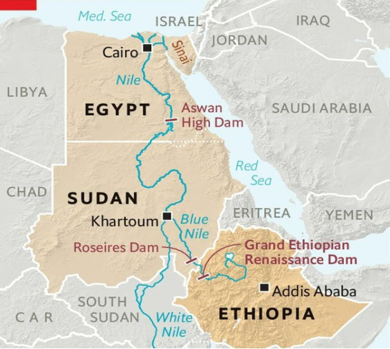
6. Map of Grand Ethiopian Renaissance Dam (GERD)
Figure 2. Map of Grand Ethiopian Renaissance Dam (GERD).
8. The Genesis and Impacts of Jonglei Canal Project
The Jonglei Canal project was proposed in 1904 by a British Civil Engineer, Sir William Garstin during the Anglo-Egyptian rule in Sudan. In 1946, the government of Egypt conducted Engineering Procurement Construction (EPC) study and plans took shape between 1954 and 1959 during the period of decolonization which included Sudanese independence in 1956. The purpose of the canal was to minimize evaporation in the Sudd Wetlands where over 50 percent of freshwater spread out into the vast and absorptive low topographical landscapes, preventing faster discharge downstream
| [15] | Howell, P et al (2010). The Jonglei Canal: Impact and Opportunity. Cambridge University Press. |
[15]
. If completed, the project would have covered a length of 350 km, a width of 54 meters, a depth of 4.5 meters, and a water carrying capacity of 25 million cubic meters per day with discharge of 4.8 billion cubic meters annually downstream to Sudan and Egypt
| [23] | Mohammed, O. (2001). Environmental and Socio-Economic Impact of the Jonglei Canal Project. Executive Organ for the Development Projects. Jonglei Canal Area. |
[23]
.
The French engineering firm, Compagnie Des Constructions Internationales (CCI) was contracted by Sudan’s Government in Khartoum to commence the digging of Jonglei Canal in 1978. When the Southerners heard about the construction of the canal, they demonstrated against it across big cities, Juba, Wau and Malakal. While the demonstrations were large and chaotic, the Juba demonstration was the largest and most chaotic in scale as it involved students in primary and secondary schools. The leader of the demonstration, Al-Zinc and three students were killed. Several politicians from the South were arrested. It has to be recalled that Chapter 5, article 14 (a) of the SPLM/A Manifesto of 31st July 1983 spelled out the construction of the Jonglei Canal and the involvement of Egyptians as the cause of massive unrest in the Southern Sudan.
The commencement of the civil war in Sudan by the SPLM/A in 1983 led to the halt of the Jonglei Canal project construction in 1984. A piece of construction equipment (bucket wheel) was left behind between Twi East and Duk County in Jonglei state where its remains.
1. Impacts of Jonglei Canal Project
1) Deaths. Four people were killed led by Al-Zinc and several other politicians were arrested in the 1978 unrest.
2) Displacement of people. The canal caused displacement of people from the northern Twi to Duk to Ayod Counties. Those displaced from those villages did not return to the original site.
3) Disruption of seasonal movement of animals. The canal construction disrupted the movement of livestock and wildlife.
4) Conflicts over grazing lands. It has led to conflicts over grazing areas. The Nuer of Ayod and Dinka of Duk fought grazing land as the canal took a large tract of land from both communities.
5) Environmental degradation. Due to spillages from construction equipment, much of the environment around the construction channels of the canal has been destroyed. It is still pretty clear today as no vegetation has re-grown at the channel of the canals. This environmental pollution was perpetuated by the fact that the governments of Egypt and Sudan did not carry out an Environmental Social Impact Assessment (ESIA).
6) Deep-Seated Mistrust. Due to the way the canal was conceived, there is a deep-seated mistrust between the South Sudanese government and the Egyptian government. While the leaders of the government of South Sudan might have their personal interests in the digging of the Jonglei Canal, South Sudanese citizens vehemently opposed it as they continued to mistrust Egypt.
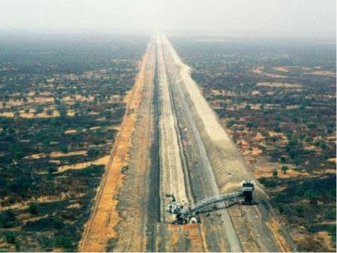
2. Pictorial of the Jonglei Canal in February-1984
Figure 3. Pictorial of the Jonglei Canal in February-1984.
9. The Role of South Sudan in Nile Basin Countries’ Politics
South Sudan plays a critical role in the balance of power between upstream and downstream countries. If South Sudan accedes to signing the Cooperation Framework Agreement (CFA) as it has done in August 2024, power will shift to the upstream countries; this will force Egypt and Sudan to renounce the 1959 treaty and accept cooperation on the basis of the CFA. However, if it doesn’t or didn’t sign the CFA, 2024, the upstream countries may decide or could have decided to act unilaterally to the detriment of the lower riparian states. In this case, with a new regime in power, Nile riparian states may renegotiate an agreement that includes the needs of all Nile Basin Countries (NBI).
Therefore, South Sudan as a middle stream state has a responsibility to bring all Nile riparian states on table so that they can negotiate a lasting solution to the river Nile basin conflicts besides negotiating a lasting peace. South Sudan plays a big role at the heart of the Nile Basin Hydropolitics because 90% of its surface area falls under the Nile Basin. In addition, most rivers that feed the Nile have confluence in South Sudan. The River Nile is therefore not only critical to South Sudan’s survival but also exposes South Sudan to conflicts not only with Sudan but also with other regional actors for instance, Egypt
| [38] | Ufulle, G. (2011). Water Security and Hydropolitics of the Nile Rivers: South Sudan’s National Security in the 21st Century. Research Gate. |
[38]
.
The use of the River Nile waters has led to an increase in the regional competition for water. All Nile basin countries are experiencing population growth at high rates
| [34] | Tadasse, G. (2012). Grand Ethiopian Renaissance Dam (GERD) and Potential Regional Conflicts. Greater Horn Publishers. |
[34]
. Gabriel Sultana (2019) argues that population increase would bring about the desire to explore water resources within their borders
| [31] | Sultana, F. (2019). Water Politics: Governance. Justice and the Right to Water. Routledge. |
[31]
. At the same time, Nile riparian states continue to depend on this river. Reports by the United Nations confirm that the Nile waters have been on the decrease over the past hundred years. In this case, South Sudan’s demand for water is bound to increase rapidly in the coming years, thereby reducing Nile waters by a bigger percentage.
The allocation of water and establishment of hydro-infrastructure is central to economic, ecological and demographic development. South Sudan depends on oil revenues for 80% of its state budget. It has great potential for Agriculture. It also has the potential for agricultural production. Building hydro-infrastructure could help generate electricity and divert water for irrigation. There has been a historic rivalry between North and South Sudan. South Sudan would face the greatest challenge of balancing cooperation with its own unilateral objectives, which its people sorely need. Governments of both countries are aware of the potential of the challenge of securing water, so they guard their own, while constantly looking for more to exploit; this fear leads countries to act unilaterally
| [39] | Waterbury, J. (1979). Introduction to Hydropolitics. Netherlands Water Institute. |
[39]
.
Option for South Sudan in Nile Basin Hydropolitics
As a middle upstream state, South Sudan is bound to take the following options: the first option is to maintain the status quo. South Sudan still benefits from the 1959 treaty agreement in that it is entitled to its annual flow of the Nile as per the agreement. Additionally, it is unclear under the post-referendum issues what share of water both South Sudan and Sudan are entitled to as they signed the treaty as one country in 1959.
The second option is to cooperate under the Nile Basin Initiative. Under this framework, all riparian states will benefit from equitable water distribution. It will also cement good relations. This is done through CFA and it is great that South Sudan ratified it in August 2024.
South Sudan last option is to pursue independent development projects. South Sudan is one of the least developed countries in the region; it is just getting on its feet. It has poor infrastructure; it has not developed major water resources and still experiences issues with sanitation. This option is detrimental to South Sudan because it still depends on Sudan for many things and if the country sets up such projects, they will take a very long time to be established.
Additionally, the entry of South Sudan as a middle-stream country is bound to change the balance of power in the Nile hydropolitics significantly. Since its independence, South Sudan was expected to sign the CFA but finally joined in August 2024. Although South Sudan still benefits from the 1959 Nile Agreement, it is nearly on the implementation of CFA-2024. Similarly, Eritrea remains an observer state since it is not located along the Nile or its tributaries, so not eligible to sign. With the CFA in place, the Nile riparian states may come together to establish another treaty that would ensure equitable use and distribution of the Nile waters and resources. If the CFA is destroyed by Egypt, downstream countries will continue to have a monopoly over the Nile. Therefore, South Sudan remains a key determinant in the shift of power in the Nile hydro-politics. The alliances that South Sudan is likely to form will most definitely border on its national interests
| [4] | Ayebare, S. (2010). A Political Storm Over the Nile. International Peace Institute. |
[4]
.
The Ministry of Water Resources and Irrigation should scale up itself to magnify the importance of water, particularly, the Nile River, to South Sudanese and its Government. There is a need for South Sudan parliament to urgently enact Nile River Management Act to regulate management of Nile resources domestically and with its neighbors.
10. The Role of China in Nile Basin Politics
The growing intensification of economic, political and social ties between China and Africa in the last 30 years is often told as a story of copper, petrodollars, emerging China towns and bilateral visits by heads of state. But perhaps the most significant way in which Chinese actors are contributing to an evolving African political-economic landscape is very seldom discussed: an unprecedented wave of hydro-infrastructure construction is taking place. Beijing is a key partner for the construction of big dams, the expansion of irrigation systems and the building of transportation canals. This is re-calibrating the domestic political economies of major African states and altering how they relate to each other. In the movie on how China met Africa, the desire for China relations with Africa is deeply rooted in socio-economic development and not politics per se.
1. Toppling Egypt’s Hydro-Hegemony
Nowhere has China’s returned to Africa been more consequential from a geopolitical water angle than in the Nile Basin, which covers eleven African states. For decades, the geopolitics of the Nile have been violent yet predictable. Despite being downstream, Egypt has for generations been the “hydro-hegemon”: the country with the best economy; the largest population; the strongest military forces; the most international prestige; and the closest partnerships with global superpowers.
Cairo invaded Sudan and Ethiopia in the nineteenth century and intervened heavily in Sudanese politics throughout the twentieth century, whilst also standing accused of interference in Uganda and Ethiopia. The reason was simple: given their profound dependence on Nile water (97 percent of domestic consumption comes from the river), Egyptian elites developed a mindset that sought to maximize their control over water used throughout the basin
| [7] | Chamgson, I. (2012). The Modern Political History of Egypt and River Nile. Misri Publishers- Cairo. |
[7]
.
Close relations with a succession of major powers-the UK (until the 1950s), the Soviet Union (until the mid-1970s) and the US ever since provided the political and financial backing to entrench Cairo’s pre-eminent position in the basin through political-legal treaties, behind the scenes influence and actual construction of infrastructure for power generation, storage and irrigation. The record-breaking Aswan Dam was built after the 1959 Nile Waters Agreement reserved the bulk of the river’s flow for Egypt. Egypt’s pre-eminence was disliked in the Nile Basin, but chronic domestic crises in Ethiopia, Uganda and Sudan meant that countries further upstream could not do much about Cairo’s hydro-hegemony. It was inconceivable that the international financial institutions would ever fund any major hydro-infrastructure projects upstream without Egypt’s explicit permission, particularly given the close alliance between Washington and Cairo.
Moreover, as dams were no longer considered very useful in the strategies of development economists (they came to be associated with mass displacement, corruption and environmental damage) there was even less of an incentive for Addis Ababa, Khartoum or Kampala to invest in such costly projects, which were only feasible with massive external support. This began to change in the 1990s when several forces internal to the region collided with China’s intensified role in Africa with massive funding for dams including GERD.
2. China Revives Old Ambitions
China’s impact on the Nile Basin has been hugely consequential in two ways. The availability of Chinese technical skills, political support and capital has given African countries options that simply did not exist prior to the 1990s. While the World Bank had become reluctant to fund major hydro-infrastructure in the developing world, Chinese companies and banks, sensing profitable business opportunities, were very eager to help Sudan and Ethiopia harness their water resources and have since become major partners in the two most ambitious dam programmes in Africa.
Sino hydro, the world’s leading dam builder, has been central to the construction of the Merowe dam and the heightening of the Roseires dam in Sudan; with the also state-owned China International Water and Electricity Corporation closely involved in these multibillion dollar projects as well. China has provided loans worth more than US$1 billion for Merowe dam and for Uganda’s biggest hydro-infrastructure project, the Karuma dam construction begun 16th December 2013 and it was commissioned on 26th September 2024. Chinese public funds and enterprises have also been crucial to Ethiopia’s dam-building. The Industrial and Commercial Bank of China is providing essential loans for the controversial Gilgel Gibe III dam after the World Bank, African Development Bank and European Investment Bank withdrew, citing ecological and social concerns. China is funding 30 percent of GERD through loan via Chinese Exim Bank.
3. Dams as “Soft Power”
But there has also been a second, more subtle form of influence exerted by Beijing. Big dams and hydro-engineering were crucial ingredients in China’s own domestic transformation. The prominent role played by mega-infrastructure projects in Chinese industrialization has not gone unnoticed and is a form of soft power: as African countries have become disillusioned with “good governance” conditionality by traditional donors, and as the West’s fortunes have declined with the Great Recession, alternative models of development and political order.
While the exact details of China’s economic miracle remain relatively poorly understood in the Nile Basin, several regimes (which several of the Western academics and my self-termed “Africa illiberal state-builders” have embraced a vision of entrenching political hegemony in their respective countries not dissimilar to that of the Chinese Communist Party.
The combination of political authoritarianism with strategic control of key sectors in the economy is seen as essential to the long-term survival of the ruling party; there is a consensus among elites that jobs need to be created and services provided to key constituencies so that significant portions of the population (though not necessarily a majority) consider continuing rule and economic stability provided by the dominant party in their interest. Big infrastructure projects are an important element in this long-term economic strategy.
The grand strategy of Africa’s most famous illiberal state-builder, the late Ethiopian Prime Minister Meles Zenawi, is a good illustration of Chinese and Russian influence. Ethiopia's ruling coalition has built a deep relationship with its counterparts in Beijing and has attempted to draw important lessons from the Chinese experience, in agricultural reform and political control as well as in instrumentalizing the financial sector and crucially, developing hydro-infrastructure.
Zenawi designed Ethiopia’s dam (GERD) programme as a nation-state-building project – tying peripheral regions to the political center and turned it into the central axis of Ethiopian foreign policy, to acquire greater autonomy from the outside world and to link with Ethiopia’s neighbors through energy flows. The programme was ironically a result of the erosion of the West’s dominance, despite the World Bank’s role in co-writing much of the technical details of the planned hydro-infrastructure. Ethiopia’s ambitions are decades old, but were politically and financially unachievable until recently. China’s huge new role in the Nile Basin has made all the difference in Ethiopia, Sudan and elsewhere.
4. Discontent at the Grassroots
The story of China’s most underestimated export, however, is not all rosy. While enthusiasm for dam-building is widespread among Nile Basin governments, large segments of the Ethiopian, Ugandan and Sudanese populations are deeply skeptical about these plans. The Merowe dam and the enlarged Roseries dam displaced more than one hundred thousand people, many of whom already had antagonistic relations with the Sudanese regime and who blamed China for working with a violent, corrupt and exclusionary elite that does not provide adequate compensation or in the resettlement for the problems that have continued to surface.
Similar anger - including mass arrests and deadly protests - erupted in Southern Ethiopia over the Gibe dams, which threaten to ruin the livelihoods of tens of thousands of local communities, who will have to make way for capital-intensive sugar production, facilitated by irrigation waters released by the new hydro-infrastructure. If Chinese soft power in the economic realm is to be sustainable, far greater support from local populations for these mega-projects that are remaking East Africa is needed. While Chinese companies cannot assume tasks that a sovereign government should be responsible for, the increasingly ugly fallout from hydro-development projects should encourage a reconsideration of how a more effective contribution can be made to sustainably develop Africa’s water resources.
11. The Role of Britain in Nile Basin Politics
When the British took control of Egypt in 1882, they very soon realized that they had become rulers of a society that was totally dependent upon the Nile. So, they understood from the very beginning that the economic stability, economic development and political stability of Egypt depended on Nile control. They also understood that in order to improve their own position within Egypt, they had to prove to the people of Egypt that they were able to provide water to them. From quite early on, the British also decided in a way to transform Egypt into a cotton farm for the textile industry in England. They also understood that in the long run, it might be very useful for London to have control over the Nile upstream of Egypt. So, if the need would arise, then they would have a potential power against Egyptian nationalism. This is known as a quite complex relationship between the hydrology of the Nile, the emerging water crisis of Egypt in the 1880s/1890s, regional power relations and the British strategy. All of these combined to create what was called in the 1890s the British road to imperialism
| [2] | Adama, O. (2012). Urban Governance and Spatial Inequality in Service Delivery: A case Study of Solid Work Management in Abuja, Nigeria. Waste Management & Research. The Journal for a Sustainable Circular Economy. Vol 30(9): 210-228. |
[2]
.
1. Talking about the Nile River
In the 1890s, there was a growing awareness in Egypt that there was a water crisis coming. The gap between the demand for water and supply of water increased. There emerged a kind of Nile discourse in Egypt. A lot of people were engaged in talking about how to secure more water for Egypt. So, in the 1890s, already people had started to talk about the need for doing something with the Nile upstream of Egypt, in Sudan, in what is today Uganda. So, when the British decided to conquer the Nile basin, that was very much in line with contemporary thought among people interested in Nile control. To control the Nile, the British did a lot of things during the 1890s. First, of course, they occupied what is today Uganda in 1894. They occupied the headwaters of the White Nile. Secondly, they occupied, together with Egypt and Sudan between 1896 and 1898 during the so-called River War. So, by 1898, they managed to control the whole White Nile.
But what about the Blue Nile? We know of course that the Blue Nile provides most of the water of the Nile. But at that time, it was very difficult to control the Blue Nile because of all the silt of the river
| [3] | Ahmed, A and Elsanabery, M. (2015). Hydrological and Environmental Impacts of Local Ethiopian Renaissance Dam on the Nile River. International Water Technology Journal. Vol 5(4): 101-121. |
[3]
. They did not have the technology to build a dam that was able to control the Blue Nile all year. So, when it comes to the Blue Nile they decided upon another strategy. They entered into an agreement with the then emperor of Ethiopia – Emperor Menelik II, an agreement where, according to the British, the Ethiopians promised not to take any water from the Blue Nile without the prior notification of the British in Cairo
| [27] | Settel, A. (2015). The Genesis of Nile River: Past, Present and Future. Palgrave. |
[27]
. This was the 1902 agreement according to the British story of it. So, by 1902, Britain controlled Uganda, Sudan, and Egypt - the whole area around Lake Victoria. It also controlled Kenya. And they had an agreement with Ethiopia, which secured the Blue Nile waters for Egypt and the Sudan. So, by 1902, Britain was the ruler of the whole Nile basin.
2. Taking the Nile River ‘in hand’
In about 1890, the British made it very, very clear to the other European powers struggling to get control of territories in Africa, that the Nile basin should be a British sphere of interest. This was in a way acknowledged by the other European powers. By the beginning of the 20
th century, the British had diplomatic agreements with their European rivals acknowledging that the Nile basin was indeed a British sphere of interest. These agreements did not guarantee British control of the Nile but they made it possible. Britain had in a way a green light for implementing their own Nile basin strategy, which of course developed during the 1890s and the first decade of the 20
th century into a real comprehensive strategy for utilizing the Nile water in accordance with the interests of the British Empire. The British brought engineers and water planners from India to Egypt. These technicians were very experienced guys. They gave them a lot of funds and a lot of political freedom so they really could take the Nile in hand. That was in a way the slogan of the British: “We want to take the Nile River in hand”
| [41] | Williamson, D. (1958). Taking River Nile in the Hands. British Water Resources Institute-London. |
[41]
. “We want to turn the gifts of nature into the benefit of humankind”
| [28] | Sortori, P. (1999). The River Nile Historical Disputes. Journal of Modern African Studies. Vol. 35(4): 675-694. |
[28]
.
The British were the first to really conceive of the Nile as one hydrological unit and therefore as one planning unit. From the 1890s, they came up with a number of plans: The Aswan Dam, they had plans for, the dam on Lake Tana in Ethiopia, they had plans for building dams on Lake Victoria in Uganda and they had plans for building Jonglei Canal through the South of Sudan. Most of the plans that people have been working on during the whole of the 20th century were plans drawn up by the British at the beginning of the century.
The British had very, very ambitious plans for the Nile. Some of the people they met thought that they were following on the footsteps of the builders of the pyramids - but that their plans were much more important. The plans that some of these water engineers had - they wanted to tame the Nile. Not only the British water planners, but all the British politicians were very ambitious indeed when it came to controlling the Nile. They didn't succeed in everything of course.
But at the turn of the century, they were really at the forefront. They built the Aswan Dam, the biggest reservoir of its kind in the world at that time in Egypt. And they had attempted to build a canal across the then Southern Sudan on a scale that nobody else anywhere was thinking about at that same time. However, their plans did not succeed as the SPLA stopped the construction of the canal in 1984.
When the British first started to develop Nile control in Egypt, they tried to improve the existing irrigation system that they found when they came. But very soon, they started to change the system into what they called perennial - that is an all-year irrigation system produces harvest for three seasons a year. The British were so concerned with improving the system of all-year irrigation because what they needed all the time was more water during the summer. The more water during the summertime, the more cotton they could cultivate. They tried to turn the fertile deserts of Egypt into an area that produces cotton for export in order to both create political stability in Egypt and economic wealth for Egypt. The British thought that this strategy was in the interest of the British and in the interest of the Egyptian people.
3. Guardians of the Nile
During the first decades of the 20
th century, the British regarded themselves as the guardians of the Nile water, as the rulers of the Nile basin, as that political force that finally made it possible to turn the gifts of the Nile to the benefit of the people and to the benefits of the British Empire of course. But slowly, perhaps mainly because of a stronger anti-British political movement in Egypt, which ended of course in the Egyptian revolution in 1919 and perhaps (there was) a sign that the cotton farm in Egypt might be going extinct. So, what they did was to give more and more emphasis to the development of Sudan so that they can acquire the cotton too. The British wanted to use Nile waters in the Sudan for two reasons. They thought it was possible to grow cotton in Sudan. In 1902, they had discovered that it was possible to build a huge - perhaps the world’s biggest - cotton farm in the Gezira area, an area between the White Nile and the Blue Nile in the Sudan
| [19] | Mahmoud, E. (2001). Environmental Scarcity, Hydropolitics and the Nile: Population Concentration, Water Scarcity and the Changing Domestic and Foreign Politics of the Sudan. Published Thesis of Social Studies, the Haque-Netherlands. |
[19]
. They had fantastically ambitious plans for the Gezira scheme that envisioned an area bigger than the whole Nile Delta in Egypt.
As explained earlier, the Great Britain wanted to turn this area into a cotton-producing region because there was still a need in Britain for cotton. They wanted to substitute this kind of cotton in case Egyptian cotton became difficult to access if political problems between Egypt and Britain emerged. From the very beginning, the British thought that Sudan geopolitically speaking, held the key to Egypt. Why? They said and further thought that the Nile was coming far from the South, crossing three climatic zones and thousands of different ethnic groups of people. It would be very difficult to control from a downstream state like Egypt. But they also thought that by doing more hydrological work in Sudan, then it would be possible to develop a Sudan which would be more independent from Egypt. Moreover, the Britain hoped to use Sudan, a newly independent from Egypt as a kind of leverage against Egyptian nationalism.
So, they had dual purpose for the Gezira scheme. It would increase cotton production in Sudan for the benefit of the British textile industry. While signing, to Egypt and also to the Sudanese people that “Egypt was not really in control of all the Nile, the Nile is running through Sudan”
| [8] | Damala, R. (1999). Is Egypt the Really Owner of River Nile? African Union Briefs. Addis Ababa. |
[8]
. Then this begs the question. Who had the power in Sudan? The British had the power in Sudan, which meant that Egypt had to realize they would not always do what they wanted to do to upstream countries, because in Sudan, the British and also the Sudanese had plans to use the Nile. The Gezira was a way to create a rift between Egypt and Sudan and also create a Sudan more independent from Egypt.
So, when it comes to the Nile, the British in the Nile basin, then it made us to talk about a kind of imperialism that was both built and did not build. In other areas of the Nile Basin, they did not do that much for the same reasons. They put much more emphasis on the development in northern Sudan and Egypt than they did on the then Southern Sudan or present-day Uganda and present-day Kenya. These regions were meant not to use Nile waters in the spirit of 1929 and 1959 Agreements. So, there were viewed as not having played the same crucial role in the whole British scrambling strategy. It might be plausible to argue that the way the British developed Nile control increased the regional inequalities in the Nile basin. At the same time, it is also very important to acknowledge that the British were the first to really approach the whole Nile basin as one planning unit and, in this sense, as one hydrological unit. Britain was an imperial power with imperial strategic concerns. They also played the deepest power politics in the Nile basin.
12. Conclusions
The study has globally scrutinized and profoundly surveyed hydro-politics. It begun by appreciating the importance of water resources and the competition associated with these resources. While the study noted the characteristics of hydro-states, it noted common differences amongst Nile Basin Initiative countries. Besides, the study discussed theories of hydro-politics, analysis of Nile water treaties signed, genesis of Aswan high dam and Egypt conviction. Although the study acknowledged the upstream and downstream countries’ politics, its comparatively analyzed Ethiopia, Egypt and Sudan on the Grand Ethiopia Renaissance Dam (GERD) and potential conflicts. Moreover, the study discussed Jonglei canal and its impacts, the role of South Sudan in Nile Basin Initiative, the role of China in Nile Basin politics as well as the role of Britain in Nile Basin politics. From the empirical literature scrutiny and surveys, it is imperative to conclude that comparative hydro-politics is critical for effective cooperation and management of water resources. However, Egypt has asserted its hegemony in refusing to recognize the Cooperative Framework Agreement (CFA) of 2024. The quickest Egypt joins CFA 2024, the peaceful hydro-environment of the region and the world.
Abbreviations
CCI | Compagnie Des Constructions Internationales |
CFA | Cooperative Framework Agreement |
DRC | Democratic Republic of Congo |
EPC | Engineering Procurement Constructions |
ESIA | Environmental Social Impact Assessment |
GDP | Gross Democratic Product |
GERD | Grand Ethiopian Renaissance Dam |
ICJ | International Court of Justice |
NBI | Nile Basin Initiative |
UK | United Kingdom |
USA | United States of America |
Author Contributions
Jacob Dut Chol Riak is the sole author. The author read and approved the final manuscript.
Conflicts of Interest
The author declares no conflicts of interest.
References
| [1] |
Abdalla, H. (1971). The 1959 Nile Waters Agreement in Sudanese-Egyptian Relations. Taylor & Francis.
|
| [2] |
Adama, O. (2012). Urban Governance and Spatial Inequality in Service Delivery: A case Study of Solid Work Management in Abuja, Nigeria. Waste Management & Research. The Journal for a Sustainable Circular Economy. Vol 30(9): 210-228.
|
| [3] |
Ahmed, A and Elsanabery, M. (2015). Hydrological and Environmental Impacts of Local Ethiopian Renaissance Dam on the Nile River. International Water Technology Journal. Vol 5(4): 101-121.
|
| [4] |
Ayebare, S. (2010). A Political Storm Over the Nile. International Peace Institute.
|
| [5] |
Batstone, R. (1959). Water Tensions and Failure of Cooperation. Wool-smith Publishers.
|
| [6] |
Carlson, M. (2016). Hydro-politics and a State. Prentice.
|
| [7] |
Chamgson, I. (2012). The Modern Political History of Egypt and River Nile. Misri Publishers- Cairo.
|
| [8] |
Damala, R. (1999). Is Egypt the Really Owner of River Nile? African Union Briefs. Addis Ababa.
|
| [9] |
Dellapenna, J. (1997). The Nile as a Legal and Political Structure. Peking University.
|
| [10] |
Ethiopia Today New, 2011.
|
| [11] |
Ezbakha, F and Brehaut, C. (2021). Hydropolitics Remains as Politics. Palgrave.
|
| [12] |
Gamal, T. (2015). Nile Water Agreement. Water Management Institute. Cairo-Egypt.
|
| [13] |
Godana, B. (1985). Africa’s Shared Water Resources: Legal and Institutional Aspects of the Nile, Niger and Senegal River Systems. Francis Printer, Ltd. London.
|
| [14] |
Hassen, A. (2014). Water Resources and Corporate Social Responsibility. Lagos Publishers.
|
| [15] |
Howell, P et al (2010). The Jonglei Canal: Impact and Opportunity. Cambridge University Press.
|
| [16] |
Klare, M. (2002). Resources Wars: The New Landscape of Global Conflict. Henry Hott and Company.
|
| [17] |
Kliot, N. (2012). Water Resources and Conflict in the Middle East. Routledge.
|
| [18] |
Knobelsdorf, V. (1999). The Nile Water Agreements: Imposition and Impacts of Trans-boundary Legal System. Yale University Press.
|
| [19] |
Mahmoud, E. (2001). Environmental Scarcity, Hydropolitics and the Nile: Population Concentration, Water Scarcity and the Changing Domestic and Foreign Politics of the Sudan. Published Thesis of Social Studies, the Haque-Netherlands.
|
| [20] |
Mekonen, N et al. (2014). Eastern Nile Basin Water System Simulation Using Hec-Ressim Model Part of the Water Resource Management Commons. Water Development Institute.
|
| [21] |
Methari, T. (2017). A Regional Power in the Making: Ethiopian Diplomacy in the Horn of Africa. Ethiopian’s Diplomacy in the Horn of Africa.
|
| [22] |
Mitchell, J. (2017). The Epistemology of Emotional Experience. Dialectical. Vol 71(5): 192-212.
|
| [23] |
Mohammed, O. (2001). Environmental and Socio-Economic Impact of the Jonglei Canal Project. Executive Organ for the Development Projects. Jonglei Canal Area.
|
| [24] |
Molinga, P. (2008). Water, Politics and Development: Framing a Political Sociology of Water Resources Management. Journal of Water Alternatives. Vol 1(1): 7-23.
|
| [25] |
Obengo, J. (2016). Hydropolitics of the Nile: The Case of Ethiopia and Egypt. African Security Review. Vol 25(1): 1-9.
|
| [26] |
Riak, J. (2023). Introduction to Comparative Politics: Political Conundrums and the Changing World. Africa World Books Press.
|
| [27] |
Settel, A. (2015). The Genesis of Nile River: Past, Present and Future. Palgrave.
|
| [28] |
Sortori, P. (1999). The River Nile Historical Disputes. Journal of Modern African Studies. Vol. 35(4): 675-694.
|
| [29] |
Sievers, E. (2011). Theories on Territorial Sovereignty: A Reappraisal. Journal of Sharia & Law. Vol 41(3): 118-129.
|
| [30] |
Swain, M. (2002). Water Politics and Conflicts. Petersen Publications.
|
| [31] |
Sultana, F. (2019). Water Politics: Governance. Justice and the Right to Water. Routledge.
|
| [32] |
Tadese, J. (2020). The Ground Ethiopian Renaissance Dam (GERD): Diplomatic War Between Ethiopia and Egypt. Power Relation Hegemony and Inequality. Basic Books.
|
| [33] |
Tadasse, G. (2017). Ethiopia Hydropower Development and Nile Basin Hydropolitics. Aims Press.
|
| [34] |
Tadasse, G. (2012). Grand Ethiopian Renaissance Dam (GERD) and Potential Regional Conflicts. Greater Horn Publishers.
|
| [35] |
Tesfaye, Z. (2017). Hydropolitics and the Impacts on Ethiopian Government. Addis Ababa University Press.
|
| [36] |
Tedla, N. (2013). Analysis of Past Agreements on the Nile on View of the Law of Treaty and CFA. Nile Publishers.
|
| [37] |
Turton, A. (2000). A Cryptic Hydro-political History of the Nile for the Students of Hydropolitics. African Water Issues Research Unit. University of Pretoria.
|
| [38] |
Ufulle, G. (2011). Water Security and Hydropolitics of the Nile Rivers: South Sudan’s National Security in the 21st Century. Research Gate.
|
| [39] |
Waterbury, J. (1979). Introduction to Hydropolitics. Netherlands Water Institute.
|
| [40] |
WB, Report, 1997.
|
| [41] |
Williamson, D. (1958). Taking River Nile in the Hands. British Water Resources Institute-London.
|
| [42] |
Zeitoum, M. (2010). Power, Hegemony and Critical Hydropolitics: Trans-boundary Water Management, Principles and Practices. Basic Books.
|
Cite This Article
-
APA Style
Riak, J. D. C. (2025). Understanding Comparative Hydropolitics: A Regional Scrutiny with Profound Global Surveys. International Journal of European Studies, 9(1), 23-40. https://doi.org/10.11648/j.ijes.20250901.14
 Copy
|
Copy
|
 Download
ACS Style
Riak, J. D. C. Understanding Comparative Hydropolitics: A Regional Scrutiny with Profound Global Surveys. Int. J. Eur. Stud. 2025, 9(1), 23-40. doi: 10.11648/j.ijes.20250901.14
Copy
|
Download
AMA Style
Riak JDC. Understanding Comparative Hydropolitics: A Regional Scrutiny with Profound Global Surveys. Int J Eur Stud. 2025;9(1):23-40. doi: 10.11648/j.ijes.20250901.14
Copy
|
Download
-
@article{10.11648/j.ijes.20250901.14,
  author = {Jacob Dut Chol Riak},
  title = {Understanding Comparative Hydropolitics: A Regional Scrutiny with Profound Global Surveys
},
  journal = {International Journal of European Studies},
  volume = {9},
  number = {1},
  pages = {23-40},
  doi = {10.11648/j.ijes.20250901.14},
  url = {https://doi.org/10.11648/j.ijes.20250901.14},
  eprint = {https://article.sciencepublishinggroup.com/pdf/10.11648.j.ijes.20250901.14},
  abstract = {The study explored hydro-politics comparatively with regional scrutiny and profound global surveys. Hydropolitics emerged as an interesting sub-field of comparative politics during the cold war period in 1970s. While hydro-politics is about state interest in the management of water resources, comparative hydro-politics is about different states interests in the management and cooperation on sharing and ownerships of water resources. Given that water is a trans-boundary resource that is susceptible to risks and conflicts, understanding politics around water resource is critical for the region and the world. The study regionally scrutinized hydro-politics on the case of Ethiopia, Egypt and Sudan using the Grand Ethiopia Renaissance Dam Project (GERD). It argues that the conflicts and tensions around the upstream and downstream countries can be regulated by the Cooperative Framework Agreement (CFA) of 2024 that has clearly articulated the equitable sharing of the water resources from River Nile. The study then analyzed hydro-political theories such as treaty succession and territorial sovereignty in management, sharing and ownership of water resources. Additionally, the study dived into the role of halted Jonglei canal and its impacts on the citizens across Jonglei state. The study also reviewed the role of South Sudan, the role of China and the role of Britain in Nile basin politics. Overall, the study used comparative method, process-tracing and case studies in scrutinizing and surveying hydro-politics in Africa and the world. The study found out that water resources have been associated with tensions, conflicts and wars and thus to avoid these catastrophes, cooperation agreements must be signed and upheld by the states sharing water resources. The eleven countries of the Nile Basin Initiative (NBI) from both the upstream and downstream must all rectify and implement the Cooperative Framework Agreement (CFA) of 2024. This is globally applicable to other countries that are sharing water resources in North America, South America, Europe, Asia, Middle East and Oceanic regions that Cooperative Framework Agreements (CFAs) are useful instruments of peaceful management of shared water resources. While the study noted the influence of Arab Republic of Egypt on the management of water resources, the study concludes that Egypt should join CFA-2024 and negotiates her rights within the framework.
},
 year = {2025}
}
Copy
|
Download
-
TY  - JOUR
T1  - Understanding Comparative Hydropolitics: A Regional Scrutiny with Profound Global Surveys

AU  - Jacob Dut Chol Riak
Y1  - 2025/06/23
PY  - 2025
N1  - https://doi.org/10.11648/j.ijes.20250901.14
DO  - 10.11648/j.ijes.20250901.14
T2  - International Journal of European Studies
JF  - International Journal of European Studies
JO  - International Journal of European Studies
SP  - 23
EP  - 40
PB  - Science Publishing Group
SN  - 2578-9562
UR  - https://doi.org/10.11648/j.ijes.20250901.14
AB  - The study explored hydro-politics comparatively with regional scrutiny and profound global surveys. Hydropolitics emerged as an interesting sub-field of comparative politics during the cold war period in 1970s. While hydro-politics is about state interest in the management of water resources, comparative hydro-politics is about different states interests in the management and cooperation on sharing and ownerships of water resources. Given that water is a trans-boundary resource that is susceptible to risks and conflicts, understanding politics around water resource is critical for the region and the world. The study regionally scrutinized hydro-politics on the case of Ethiopia, Egypt and Sudan using the Grand Ethiopia Renaissance Dam Project (GERD). It argues that the conflicts and tensions around the upstream and downstream countries can be regulated by the Cooperative Framework Agreement (CFA) of 2024 that has clearly articulated the equitable sharing of the water resources from River Nile. The study then analyzed hydro-political theories such as treaty succession and territorial sovereignty in management, sharing and ownership of water resources. Additionally, the study dived into the role of halted Jonglei canal and its impacts on the citizens across Jonglei state. The study also reviewed the role of South Sudan, the role of China and the role of Britain in Nile basin politics. Overall, the study used comparative method, process-tracing and case studies in scrutinizing and surveying hydro-politics in Africa and the world. The study found out that water resources have been associated with tensions, conflicts and wars and thus to avoid these catastrophes, cooperation agreements must be signed and upheld by the states sharing water resources. The eleven countries of the Nile Basin Initiative (NBI) from both the upstream and downstream must all rectify and implement the Cooperative Framework Agreement (CFA) of 2024. This is globally applicable to other countries that are sharing water resources in North America, South America, Europe, Asia, Middle East and Oceanic regions that Cooperative Framework Agreements (CFAs) are useful instruments of peaceful management of shared water resources. While the study noted the influence of Arab Republic of Egypt on the management of water resources, the study concludes that Egypt should join CFA-2024 and negotiates her rights within the framework.

VL  - 9
IS  - 1
ER  -
Copy
|
Download