For efficient management of water-related assets, agricultural planning, lowering disaster risks, for educational and urban planning, it is essential to determine climate types. The modified Köppen climate classification of East and Central Oromia was examined in this study, along with shifts in climate type and spatio-temporal variability from 1991 to 2020. This study basis updated rainfall and temperature data from local meteorological stations, in contrast to earlier research that mainly relied on global datasets to characterize climate types at national and global scales. The study area's distinct climatic diversity is a result of its complex topography, which includes highlands, midlands, and natural forest areas. A statistical approach applied to determine Köppen climate types across the study area. The study results determined three major climates groups-tropical, temperate, and arid-and additional the seven sub-climate types identified. The wet, warm summers and dry winter climate dominate the west, central, and east parts of the study area of Shewa, Hararge and Arsi highland areas. The semi-arid steppe (hot) climate type prevails in the Eastern areas. The research finding further observed that the Aw, BSh, Cwb and BWh climate types increased by 2.3%, 1.1%, 0.3% and 0.2% of total land area, respectively. In contrast, Cfb, Cfa and Cwa climate types decreased by 4.1%, 0.3% and 0.1% of the total land area, respectively. This trend indicates long rainy periods have become shorter compared to previous periods. From the study finding, observed changes reveal a shift from cooler and more humid temperate climates toward warmer and drier climate types, suggesting an expansion of long dry and cold-season areas across the study area.
| Published in | International Journal of Sustainable and Green Energy (Volume 15, Issue 1) |
| DOI | 10.11648/j.ijsge.20261501.16 |
| Page(s) | 66-74 |
| Creative Commons |
This is an Open Access article, distributed under the terms of the Creative Commons Attribution 4.0 International License (http://creativecommons.org/licenses/by/4.0/), which permits unrestricted use, distribution and reproduction in any medium or format, provided the original work is properly cited. |
| Copyright |
Copyright © The Author(s), 2026. Published by Science Publishing Group |
Koppen, Climate Types, Classification, Central Oromia
First | Second | Third | Description | Criterion | Definition |
|---|---|---|---|---|---|
A | Tropical | Not (B) & Tcold ≥ 18 | |||
f | – Rainforest | Pdry ≥ 60 | |||
m | – Monsoon | Not (Af) & Pdry ≥ 100 − MAP/25 | |||
w | – Savannah | Not (Af) & Pdry < 100 − MAP/25 | |||
B | Arid | MAP < 10 × Pthreshold | |||
W | – Desert | MAP < 5 × Pthreshold | |||
S | – Steppe | MAP ≥ 5 × Pthreshold | |||
h | – Hot | MAT ≥ 18 | BSh = Hot semi-arid climate | ||
k | – Cold | MAT < 18 | |||
C | Temperate | Not (B) & Thot > 10 & 0 < Tcold < 18 | |||
w | – Dry winter | Pwdry < Pswet / 10 | |||
s | – Dry summer | Not (w) & Psdry < 40 & Psdry < Pwwet / 3 | |||
f | – Without dry season | Not (s) or (w) | |||
a | – Hot summer | Thot ≥ 22 | |||
b | – Warm summer | Not (a) & Tmon10 ≥ 4 | |||
c | – Cold summer | Not (a or b) & 1 ≤ Tmon10 < 4 | |||
D | Boreal | Not (B) &Thot > 10 & Tcold ≤ 0 | |||
w | – Dry winter | Pwdry < Pswet / 10 | |||
s | – Dry summer | Not (w) & Psdry < 40 & Psdry < Pwwet / 3 | |||
f | – Without dry season | Not (s) or (w) | |||
a | – Hot summer | Thot ≥ 22 | |||
b | – Warm summer | Not (a) & Tmon10 ≥ 4 | |||
c | – Cold summer | Not (a), (b) or (d) | |||
d | – Very cold winter | Not (a or b) & Tcold < −38 | |||
E | Polar | Not (B) & Thot ≤ 10 | |||
T | – Tundra | Thot > 0 | |||
F | – Frost | Thot ≤ 0 |
Observed Climate types |
|
|
|
|
|
|
| Remark |
|---|---|---|---|---|---|---|---|---|
1991-2000 | 39.7% | 11.5% | 0.0% | 0.4% | 11.9% | 0.7% | 35.7% | |
2001-2010 | 39.7% | 14.6% | 0.7% | 0.1% | 15.5% | 1.2% | 28.2% | Semi-arid increased |
2011-2020 | 42.3% | 13.6% | 0.1% | 0.4% | 2.3% | 0.7% | 40.5% | More Shift |
1991-2020 | 42.0% | 12.6% | 0.2% | 0.1% | 7.8% | 0.6% | 36.% | |
Ranking by area coverage | 1st | 3rd | 6th | 7th | 4th | 5th | 2nd | |
Change | +2.3% | +1.1% | +0.2% | -0.3% | -4.1% | -0.1% | +0.3% | Long dry and cold season area increased |
MSc | Master of Science |
MAP | Mean Annual Precipitation, |
MAT | Mean Annual Temperature |
DEM | Digital Elevation Model |
ECO MSC | Eastern and Central Oromia Meteorological Research Service Centre |
ENACTS | Enhancing National Climate Service |
EMI | Ethiopian Meteorological Institute |
| [1] | Wang T, Zhou D, Shen X. Spatial-temporal variations of Köppen climate types in China. 2021; 32(4): 483–96. |
| [2] | Zhang X, Yan X. Spatiotemporal change in geographical distribution of global climate types in the context of climate warming. Clim Dyn. 2014; 43(3): 595–605. |
| [3] | Dubreuil V, Fante KP, Planchon O, Sant’anna Neto JL. Climate change evidence in Brazil from Köppen’s climate annual types frequency. Int J Climatol. 2019; 39(3): 1446–56. |
| [4] | Pražnikar J. Particulate matter time-series and Köppen-Geiger climate classes in North America and Europe. Atmos Environ. 2017; 150: 136–45. |
| [5] | Poulter B, Ciais P, Hodson E, Lischke H, Maignan F, Plummer S, et al. Plant functional type mapping for earth system models. Geosci Model Dev. 2011; 4(4): 993–1010. |
| [6] | Lasantha V, Oki T, Tokuda D. Data‐Driven versus Köppen–Geiger Systems of Climate Classification. Adv Meteorol. 2022; 2022(1): 3581299. |
| [7] | Tapiador FJ, Moreno R, Navarro A. Consensus in climate classifications for present climate and global warming scenarios. Atmos Res. 2019; 216: 26–36. |
| [8] | Williams JW, Jackson ST, Kutzbach JE. Projected distributions of novel and disappearing climates by 2100 AD. Proc Natl Acad Sci. 2007; 104(14): 5738–42. |
| [9] | Sandel B, Arge L, Dalsgaard B, Davies RG, Gaston KJ, Sutherland WJ, et al. The Influence of Late Quaternary Climate-Change Velocity on Species Endemism. 2011;(October). |
| [10] | Zeroual A, Assani AA, Meddi M, Alkama R. Assessment of climate change in Algeria from 1951 to 2098 using the Köppen – Geiger climate classification scheme. 2018;(0123456789). |
| [11] | Washington R, Harrison M, Conway D, Black E, Challinor A, Grimes D, et al. African climate change: taking the shorter route. Bull Am Meteorol Soc. 2006; 87(10): 1355–66. |
| [12] | Dinku T, Thomson MC, Cousin R, del Corral J, Ceccato P, Hansen J, et al. Enhancing national climate services (ENACTS) for development in Africa. Clim Dev. 2018; 10(7): 664–72. |
| [13] | Dinku T, Block P, Sharoff J, Hailemariam K, Osgood D, del Corral J, et al. Bridging critical gaps in climate services and applications in Africa. Earth Perspect. 2014; 1(1): 15. |
| [14] | Dinku T. Challenges with availability and quality of climate data in Africa. 2019; |
| [15] | Cui D, Liang S, Wang D, Liu Z. A 1 km global dataset of historical (1979 – 2013) and future (2020 – 2100) Köppen – Geiger climate classification and bioclimatic variables. 2021; 5087–114. |
| [16] | Peel MC, Finlayson BL, Mcmahon TA. Updated world map of the K ¨ oppen-Geiger climate classification. 2007; 1633–44. |
| [17] | Beck HE, Zimmermann NE, McVicar TR, Vergopolan N, Berg A, Wood EF. Present and future Köppen-Geiger climate classification maps at 1-km resolution. Sci data. 2018; 5(1): 1–12. |
APA Style
Balcha, G. D., Wami, A. H. (2026). Evolving Climate Classification of East and Central Oromia in a Changing Climate Using the Koppen–Geiger Method. International Journal of Sustainable and Green Energy, 15(1), 66-74. https://doi.org/10.11648/j.ijsge.20261501.16
ACS Style
Balcha, G. D.; Wami, A. H. Evolving Climate Classification of East and Central Oromia in a Changing Climate Using the Koppen–Geiger Method. Int. J. Sustain. Green Energy 2026, 15(1), 66-74. doi: 10.11648/j.ijsge.20261501.16
@article{10.11648/j.ijsge.20261501.16,
  author = {Gashawun Dereje Balcha and Abdisa Hirko Wami},
  title = {Evolving Climate Classification of East and Central Oromia in a Changing Climate Using the Koppen–Geiger Method},
  journal = {International Journal of Sustainable and Green Energy},
  volume = {15},
  number = {1},
  pages = {66-74},
  doi = {10.11648/j.ijsge.20261501.16},
  url = {https://doi.org/10.11648/j.ijsge.20261501.16},
  eprint = {https://article.sciencepublishinggroup.com/pdf/10.11648.j.ijsge.20261501.16},
  abstract = {For efficient management of water-related assets, agricultural planning, lowering disaster risks, for educational and urban planning, it is essential to determine climate types. The modified Köppen climate classification of East and Central Oromia was examined in this study, along with shifts in climate type and spatio-temporal variability from 1991 to 2020. This study basis updated rainfall and temperature data from local meteorological stations, in contrast to earlier research that mainly relied on global datasets to characterize climate types at national and global scales. The study area's distinct climatic diversity is a result of its complex topography, which includes highlands, midlands, and natural forest areas. A statistical approach applied to determine Köppen climate types across the study area. The study results determined three major climates groups-tropical, temperate, and arid-and additional the seven sub-climate types identified. The wet, warm summers and dry winter climate dominate the west, central, and east parts of the study area of Shewa, Hararge and Arsi highland areas. The semi-arid steppe (hot) climate type prevails in the Eastern areas. The research finding further observed that the Aw, BSh, Cwb and BWh climate types increased by 2.3%, 1.1%, 0.3% and 0.2% of total land area, respectively. In contrast, Cfb, Cfa and Cwa climate types decreased by 4.1%, 0.3% and 0.1% of the total land area, respectively. This trend indicates long rainy periods have become shorter compared to previous periods. From the study finding, observed changes reveal a shift from cooler and more humid temperate climates toward warmer and drier climate types, suggesting an expansion of long dry and cold-season areas across the study area.},
 year = {2026}
}
TY  - JOUR
T1  - Evolving Climate Classification of East and Central Oromia in a Changing Climate Using the Koppen–Geiger Method
AU  - Gashawun Dereje Balcha
AU  - Abdisa Hirko Wami
Y1  - 2026/03/14
PY  - 2026
N1  - https://doi.org/10.11648/j.ijsge.20261501.16
DO  - 10.11648/j.ijsge.20261501.16
T2  - International Journal of Sustainable and Green Energy
JF  - International Journal of Sustainable and Green Energy
JO  - International Journal of Sustainable and Green Energy
SP  - 66
EP  - 74
PB  - Science Publishing Group
SN  - 2575-1549
UR  - https://doi.org/10.11648/j.ijsge.20261501.16
AB  - For efficient management of water-related assets, agricultural planning, lowering disaster risks, for educational and urban planning, it is essential to determine climate types. The modified Köppen climate classification of East and Central Oromia was examined in this study, along with shifts in climate type and spatio-temporal variability from 1991 to 2020. This study basis updated rainfall and temperature data from local meteorological stations, in contrast to earlier research that mainly relied on global datasets to characterize climate types at national and global scales. The study area's distinct climatic diversity is a result of its complex topography, which includes highlands, midlands, and natural forest areas. A statistical approach applied to determine Köppen climate types across the study area. The study results determined three major climates groups-tropical, temperate, and arid-and additional the seven sub-climate types identified. The wet, warm summers and dry winter climate dominate the west, central, and east parts of the study area of Shewa, Hararge and Arsi highland areas. The semi-arid steppe (hot) climate type prevails in the Eastern areas. The research finding further observed that the Aw, BSh, Cwb and BWh climate types increased by 2.3%, 1.1%, 0.3% and 0.2% of total land area, respectively. In contrast, Cfb, Cfa and Cwa climate types decreased by 4.1%, 0.3% and 0.1% of the total land area, respectively. This trend indicates long rainy periods have become shorter compared to previous periods. From the study finding, observed changes reveal a shift from cooler and more humid temperate climates toward warmer and drier climate types, suggesting an expansion of long dry and cold-season areas across the study area.
VL  - 15
IS  - 1
ER  -
Eastern and Central Oromia Meteorological Research Service Centre, Ethiopian Meteorological Institute, Adama, Ethiopia
Biography: Gashawun Dereje Balcha is a Meteorological Researcher at Eastern and Central Oromia Meteorological Research Service Centre Adama, Ethiopia. I obtained My BSc in Statistics from Dilla University and postgraduate diploma in Meteorology science from Ethiopian Meteorological Institute. Additionally I obtained My MSc Degree in Meteorology Science from Arba Minch University, Ethiopia.

Eastern and Central Oromia Meteorological Research Service Centre, Ethiopian Meteorological Institute, Adama, Ethiopia
Biography: Abdisa Hirko Wami a researcher at the Ethiopian Meteorology Institute, East and Central Oromia Meteorological Research Service Centre (ECO-MSC). Earned both BSc and MSc in Meteorological Science from Arba Minch University of Water Technology Institute, Ethiopia. Has experience in weather forecasting, having worked as an Aeronautical Meteorology Forecaster at Bole International Airport under the Aviation Meteorology Directorate, and later as a forecaster at ECO-MSC. Currently a researcher, and serves as the acting Lead Executive Officer at ECO-MSC. Published three sole-authored and seven co-authored papers and plans to conduct research aimed at improving weather forecasting skills.

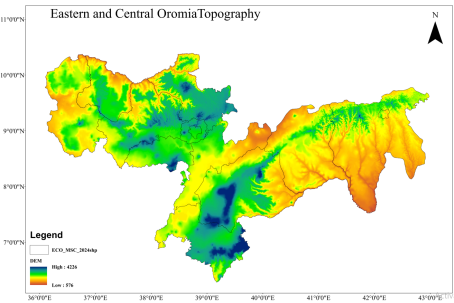
Figure 1. Digital Elevation Model of Eastern and Central Oromia.
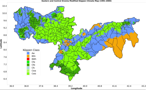
Figure 2. East and Central Oromia Köppen climate classification.
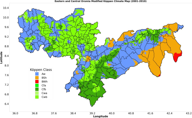
Figure 3. East and Central Oromia Köppen climate classification.
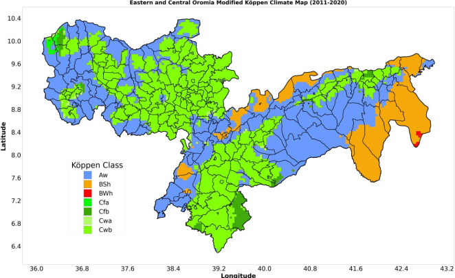
Figure 4. East and Central Oromia Köppen climate classification.
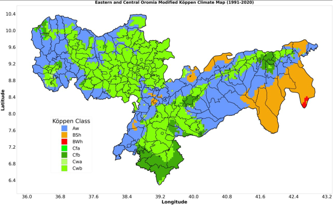
Figure 5. East and Central Oromia Köppen climate classification.
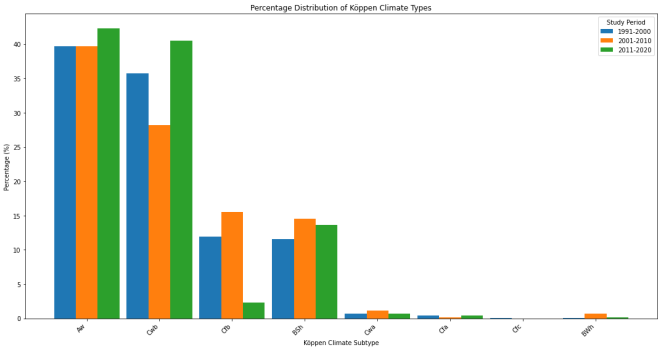
Figure 6. Distribution of sub-climate categories during 1991-2020.
Information


 Aw
Aw BSh
BSh BWh
BWh Cfa
Cfa Cfb
Cfb Cwa
Cwa Cwb
Cwb