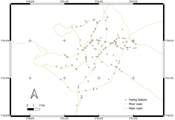
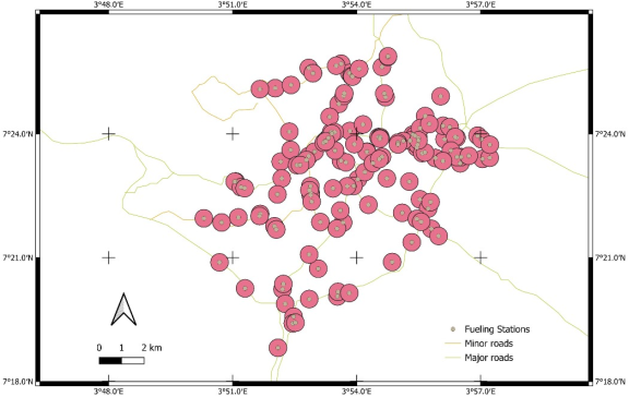
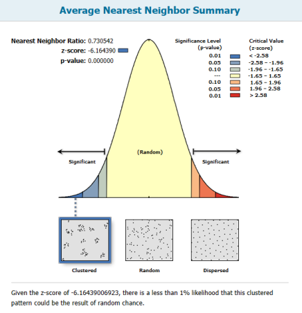
The number of petrol stations in Nigerian cities like Ibadan is growing rapidly without adhering to spatial planning regulations, particularly minimum distance requirements that raise safety concerns, such as petrol station fire risk, and emphasizes the need for spatial analysis to support sustainable urban growth. This study uses Geographic Information System techniques, government location criteria, and supporting literature to evaluate the spatial distribution of petrol stations in Ibadan Metropolis. A handheld Global Positioning System was used to obtain the coordinates of petrol stations, and the Nearest Neighbour Analysis was used to evaluate spatial patterns. GIS analysis reveals widespread overlapping buffers of petrol stations, implying areas of high cumulative risk following disregard for the required 400m buffer between petrol stations. Nearest Neighbour Analysis reveals clustering of petrol stations because the expected mean distance between petrol stations was 473.9 meters, whereas the observed mean distance was 346.1 meters. A statistically significant deviation from randomness was established by a Nearest Neighbour Ratio of 0.730542 and a Z-score of –6.164390. These findings demonstrate the inadequacies of current planning frameworks and the inadequate application of spatial planning regulations. The report suggests enforcing petrol station siting requirements and bolstering urban regulatory organizations to improve emergency readiness to lessen the effects of associated risks. Equally, further studies utilizing sophisticated spatial analytics and routine environmental evaluations are required.
| Published in | Urban and Regional Planning (Volume 11, Issue 1) |
| DOI | 10.11648/j.urp.20261101.12 |
| Page(s) | 12-20 |
| Creative Commons |
This is an Open Access article, distributed under the terms of the Creative Commons Attribution 4.0 International License (http://creativecommons.org/licenses/by/4.0/), which permits unrestricted use, distribution and reproduction in any medium or format, provided the original work is properly cited. |
| Copyright |
Copyright © The Author(s), 2026. Published by Science Publishing Group |
Petrol Stations, GIS, Cluster, Urbanisation, Regulations
Filling Station | Easting | Northing | Address/Location |
|---|---|---|---|
October 1 Filling Station | 596038.14 | 811117.92 | Oluyole Ibadan |
Adolakfilling Station | 603938.9 | 816759.65 | Old Oyo Road Samonda, Ibadan |
Agboola Petrol Station | 604930.48 | 816956.5 | Old Ife Road, Ibadan |
Agip Filling Station | 599790.59 | 817274.59 | Yemetu Oja, Ibadan |
Alleluya Petrol | 598731.4 | 814103.5 | Orita Apeerin-Beere Road, Ibadan |
Amazing Filling Station | 597626 | 812040 | Fajerninsin Cresent, Ibadan |
Ap Station | 595675.78 | 813931.1 | New Gra, Ibadan |
Ap Station | 598069.27 | 817882.79 | Oyo Road, Ibadan |
Ascon Petrol Station | 595697.48 | 820098.75 | Sango, Eleyele Road Ibadan |
Azeez Ayinla Petroleum Ltd | 597228.83 | 810682.32 | Lagos Ojoo Express Way |
Bee Deen Oil And Gas | 595946.08 | 816816.13 | Forestry Road, Jericho, Ibadan |
Bigropet Nigeria Ltd | 602002.76 | 817464.03 | Agodi Gate, Ibadan |
Bigropet Filling Station | 602071.92 | 817882.53 | Odejayi Street, Ibadan |
Bovas | 603239.76 | 817832.86 | Iwo Road Ibadan |
Bovas | 603173.47 | 818434.97 | Idera Close, Iwo Road |
Bovas Filling Station | 593942.4 | 815927.62 | Odo Ona, Apata Road Ibadan |
Bovas | 600445.67 | 821058.18 | Kenneth Dike Road, Ibadan |
Bovas | 597917.84 | 817736.35 | Queen Elizabeth Road, Mokola Ibadan |
Bovas Fuel Station | 599778.36 | 817260.51 | Adeoyo Street, Off Yemetu, Ibadan |
Bovas Petrol Station | 597191.53 | 817067.01 | Yemetu Oja, Ibadan |
Bovas Service Station | 597187.78 | 821007.77 | Royejo St, Dugbe, Ibadan |
Bovas Service Station | 600305.39 | 817924.57 | Queen Elizabeth Road, Mokola Ibadan |
Bumad Petrol Station | 600298.37 | 817918.98 | Total Garden, Ibadan |
Citee | 598484.19 | 810801.91 | Soka Area, Off Lagos/Ibadan Expressway |
Conoil Station | 597218.62 | 812672.02 | Ogunmola Street Ibadan |
Conoil Station | 596391.23 | 817343.12 | 54, Magazine Road, Ibadan |
Conoil Station | 598194.13 | 818141.79 | Oyo Road, Ibadan |
Conoil Station | 598455.25 | 813833.4 | Ogunmola Street Ibadan |
Conoil Station | 599386.33 | 816040.63 | Sabo Road, Ibadan |
Conoil Station | 600454.92 | 817043.01 | Irefin Oje Ibadan |
Nearest Neighbor Ratio: | 0.730542 |
|---|---|
z-score: | -6.164390 |
p-value: | 0.000000 |
Observed Mean Distance: | 346.1773 Meters |
|---|---|
Expected Mean Distance: | 473.8636 Meters |
Nearest Neighbor Ratio: | 0.730542 |
z-score: | -6.164390 |
p-value: | 0.000000 |
ALOHA | Aerial Locations of Hazardous Atmospheres |
BLEVE | Boiling Liquid Expanding Vapor Explosion |
DPR | Department of Petroleum Resources |
LPG | Liquefied Petroleum Gas |
NNA | Nearest Neighbour Analysis |
NNR | Nearest Neighbour Ratio |
NUPRC | Nigerian Upstream Petroleum Regulatory Commission |
PFS | Petrol Filling Station |
PMS | Premium Motor Spirit |
SDGs | Sustainable Development Goals |
| [1] | Adebayo, A. S. Ojo, A. S. Sustainable Urban Development and Location of Petroleum Stations in Akure Metropolis, Ondo State Nigeria.” International Journal of Advances in Engineering and Management (IJAEM) 2021 10(3) 804-812. |
| [2] | Adedeji, O. H., Olayinka, O. O., Badejo, A. A., & Osunde, E. O. Spatial distribution and environmental risk assessment of petrol stations in Abeokuta metropolis, Ogun state, Nigeria. Journal of Applied Sciences and Environmental Management, 2022 26(11), 1843-1850. |
| [3] | Adelekan, I. O. Urban dynamics, everyday hazards and disaster risks in Ibadan, Nigeria. Environment and Urbanization 2020 32(1): 213–232. |
| [4] | Adewuyi, G K, Sanni, T B, and Abudulawal, K A. Geospatial Distribution and Assessment of Filling Stations and Environmental Health Risks in Part of Urban Core Area of Ibadan Metropolis, Oyo State, Southwest Nigeria. International Journal of Geo-informatics and Geological Science. 2021 8(3). 12-21. |
| [5] | Afolabi, O T., Olajide, F O. and Omotayo, S K. Assessment of Safety Practices in Filling Stations in Ile-Ife, South Western Nigeria. Journal of Community Medicine and Primary Health Care. 2011 23(1&2). |
| [6] | Arokoyu, S B, Mark, O and Jochebed, A O. Petrol Filling Stations’ Location and Minimum Environmental Safety Requirements in Obio Akpor LGA, Nigeria. International Journal of Scientific Research and Innovative Technology. 2015 2(11). |
| [7] | Boudia S, Jas N. Introduction: Risk and ‘risk society’in historical perspective. History and Technology. 2007 Dec 1; 23(4): 317-31. |
| [8] | Çetinyokuş, S., and Pamuk, E. Consequence Analysis of an Industrial Accident at a Fuel Station. GU Journal of Science, 2023 Part A, 10(4), 378-391. |
| [9] | Desriani, R W. and Samyahardja, P Urban Resilience to Fire Disaster in High Density Urban Area. In Equity, Equality and Justise in Urban Housing Development, edited by Andreas Matzarakis and Beta Paramita, 2018 202-230. UPI Press. |
| [10] | Enwezor, F V O and Ojiako, J C GIS-based analysis of filling stations in Onitsha north and south local government areas in Anambra State, Nigeria. World Journal of Advanced Research and Reviews, 2024, 22(03), 141–147, |
| [11] | Gong, J, Lee, J Zhou, S and Li, S Toward Measuring the Level of Spatiotemporal Clustering of Multi-Categorical Geographic Events International Journal of Geo Information 2020 9, 440; |
| [12] | Güntay V. Rethinking The Global Politics and Leadership: Ulrich Beck’s Risk Society Versus Postmodern Politics. PAUSBED. May 2021;(44): 405-418. |
| [13] | Hasan, M N Techno-environmental risks and ecological modernisation in “double-risk” societies: reconceptualising Ulrich Beck’s risk society thesis. Local Environment 258-275 23(3) Routledge |
| [14] | Hsieh, P Y, Shearston, J A. and Hilpert, M Benzene emissions from gas station clusters: a new framework for estimating lifetime cancer risk. Journal of Environmental Health Science and Engineering 2021 19: 273–283. |
| [15] | Joseph, S A. Vulnerability and Preparedness of Energy Stations Fire Outbreaks in Ibadan and Warri, Nigeria. Individual Research Project Draft Report submitted to the Research Management Department, Nigerian Institute of Social and Economic Research. 2022 Unpolished. |
| [16] | Jia, N, Nwaogazie, I L. and Mmom, P.. Assessment of Locational Compliance Status of Petroleum Products Handling Facilities in Niger Delta Region, Nigeria. Journal of Environmental Protection, 2022 13, 750-765. |
| [17] | Macrotrends LLC Ibadan, Nigeria Population 1950-2020. 2020 Retrieved from |
| [18] |
Mohammed, M. U. Musa, I. J. and Jeb, D. N. GIS-Based Analysis of the Location of Filling Stations in Metropolitan Kano against the Physical Planning Standards. American Journal of Engineering Research (AJER) 2014 e-, pp-147-158
www.ajer.org Research Paper Open Access. |
| [19] | Ogunkan, D V Geographies of Fuel Dispensing: Locational Analysis and Conformity of Petrol Filling Stations (PFS) to Planning Standards in Ota, Nigeria. Research Square. 2022 |
| [20] | O'Sullivan, D., and Unwin, D. J. Geographic Information Analysis (2nd ed.). 2010 Wiley. |
| [21] | Qonono, K. and Lunga, W., ‘Assessing land-use regulations for petrol stations in South Africa’s major cities’, Jàmbá: Journal of Disaster Risk Studies 2025, 17(1), a1898. |
| [22] | Qonono, K. Analysis of the Fire Hazard Posed by Petrol Stations in Stellenbosch and the Degree of Risk Acknowledgement in Land-Use Planning. International Journal of Architectural and Environmental Engineering. 2024. 18(2). |
| [23] | Tah, D S GIS-Based Locational Analysis of Petrol Filling Stations in Kaduna Metropolis. Science World Journal 2017 12(2) |
| [24] | Yusuf, Y. Y. Sawa, B. A. Usman, A. K. Olorunsola K. Spatial Analysis of Petroleum Filling Stations’ Compliance to Regulatory Standards in Bauchi Metropolis, Nigeria. American Journal of Energy and Natural Resources (AJENR). 2024 3(1), |
APA Style
Joseph, S. A. (2026). Spatial Assessment of Petrol Stations in Ibadan Metropolis Nigeria. Urban and Regional Planning, 11(1), 12-20. https://doi.org/10.11648/j.urp.20261101.12
ACS Style
Joseph, S. A. Spatial Assessment of Petrol Stations in Ibadan Metropolis Nigeria. Urban Reg. Plan. 2026, 11(1), 12-20. doi: 10.11648/j.urp.20261101.12
@article{10.11648/j.urp.20261101.12,
  author = {Siji Ayodeji Joseph},
  title = {Spatial Assessment of Petrol Stations in Ibadan Metropolis Nigeria},
  journal = {Urban and Regional Planning},
  volume = {11},
  number = {1},
  pages = {12-20},
  doi = {10.11648/j.urp.20261101.12},
  url = {https://doi.org/10.11648/j.urp.20261101.12},
  eprint = {https://article.sciencepublishinggroup.com/pdf/10.11648.j.urp.20261101.12},
  abstract = {The number of petrol stations in Nigerian cities like Ibadan is growing rapidly without adhering to spatial planning regulations, particularly minimum distance requirements that raise safety concerns, such as petrol station fire risk, and emphasizes the need for spatial analysis to support sustainable urban growth. This study uses Geographic Information System techniques, government location criteria, and supporting literature to evaluate the spatial distribution of petrol stations in Ibadan Metropolis. A handheld Global Positioning System was used to obtain the coordinates of petrol stations, and the Nearest Neighbour Analysis was used to evaluate spatial patterns. GIS analysis reveals widespread overlapping buffers of petrol stations, implying areas of high cumulative risk following disregard for the required 400m buffer between petrol stations. Nearest Neighbour Analysis reveals clustering of petrol stations because the expected mean distance between petrol stations was 473.9 meters, whereas the observed mean distance was 346.1 meters. A statistically significant deviation from randomness was established by a Nearest Neighbour Ratio of 0.730542 and a Z-score of –6.164390. These findings demonstrate the inadequacies of current planning frameworks and the inadequate application of spatial planning regulations. The report suggests enforcing petrol station siting requirements and bolstering urban regulatory organizations to improve emergency readiness to lessen the effects of associated risks. Equally, further studies utilizing sophisticated spatial analytics and routine environmental evaluations are required.},
 year = {2026}
}
TY  - JOUR
T1  - Spatial Assessment of Petrol Stations in Ibadan Metropolis Nigeria
AU  - Siji Ayodeji Joseph
Y1  - 2026/01/29
PY  - 2026
N1  - https://doi.org/10.11648/j.urp.20261101.12
DO  - 10.11648/j.urp.20261101.12
T2  - Urban and Regional Planning
JF  - Urban and Regional Planning
JO  - Urban and Regional Planning
SP  - 12
EP  - 20
PB  - Science Publishing Group
SN  - 2575-1697
UR  - https://doi.org/10.11648/j.urp.20261101.12
AB  - The number of petrol stations in Nigerian cities like Ibadan is growing rapidly without adhering to spatial planning regulations, particularly minimum distance requirements that raise safety concerns, such as petrol station fire risk, and emphasizes the need for spatial analysis to support sustainable urban growth. This study uses Geographic Information System techniques, government location criteria, and supporting literature to evaluate the spatial distribution of petrol stations in Ibadan Metropolis. A handheld Global Positioning System was used to obtain the coordinates of petrol stations, and the Nearest Neighbour Analysis was used to evaluate spatial patterns. GIS analysis reveals widespread overlapping buffers of petrol stations, implying areas of high cumulative risk following disregard for the required 400m buffer between petrol stations. Nearest Neighbour Analysis reveals clustering of petrol stations because the expected mean distance between petrol stations was 473.9 meters, whereas the observed mean distance was 346.1 meters. A statistically significant deviation from randomness was established by a Nearest Neighbour Ratio of 0.730542 and a Z-score of –6.164390. These findings demonstrate the inadequacies of current planning frameworks and the inadequate application of spatial planning regulations. The report suggests enforcing petrol station siting requirements and bolstering urban regulatory organizations to improve emergency readiness to lessen the effects of associated risks. Equally, further studies utilizing sophisticated spatial analytics and routine environmental evaluations are required.
VL  - 11
IS  - 1
ER  -
Environment and Physical Infrastructure Policy Department, Nigerian Institute of Social and Economic Research (NISER), Ibadan, Nigeria
Information